
On September 3, the Waterfront Flood Mitigation Team announced preliminary reductions to the Waterfront Pump Station building were progressing. In conjunction with the smaller footprint, the design team was tasked with developing alternative landscape design concepts featuring reduced hardscaping and greater green space. View the current concept and two initial landscape alternatives below.
What do you think of the new concepts? Use the link below to submit feedback on these designs to the Waterfront Flood Mitigation Team.


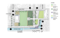
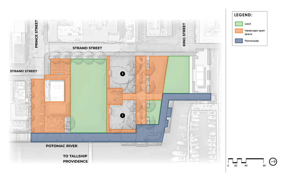
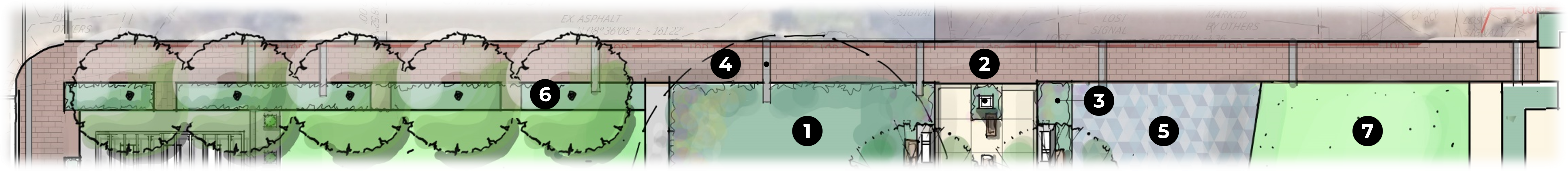
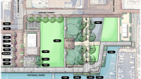
DESCRIPTION:
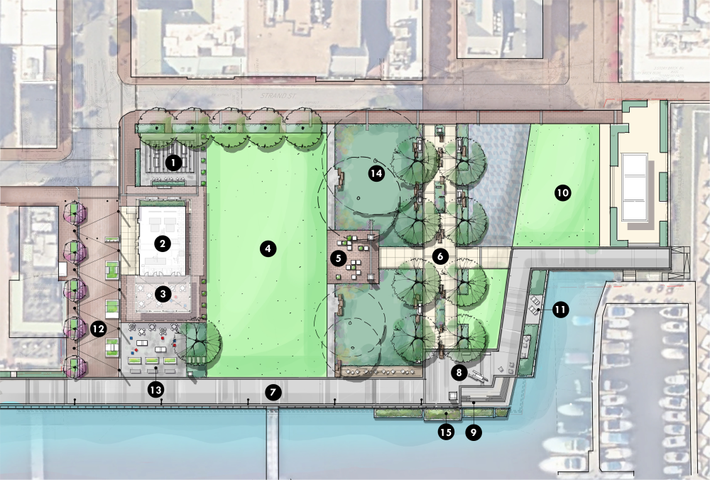
The plan to the left shows the revised pump station footprint boundary overlaid on the current site plan.
LEGEND:
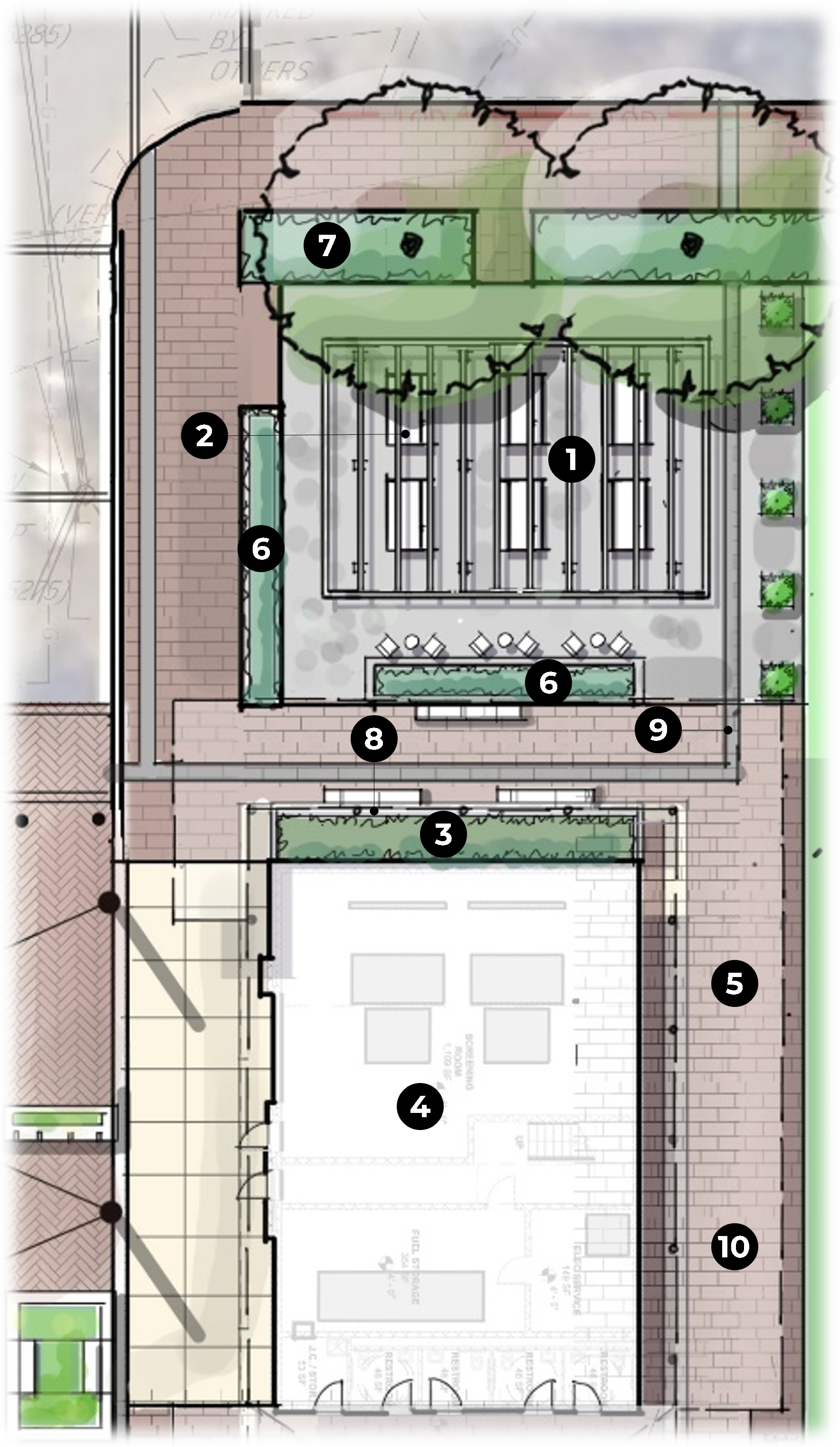
1. Trellis structure with picnic tables and catenary lighting
2. Pump station
3. Covered plaza / venue space
4. Multi-use lawn
5. Arrival plaza with crate-inspired seating
6. Wales Alley River Gateway
7. Promenade
8. Promenade plaza with seating / art / signage
9. Waterfront steps / seat wall
10. N. Waterfront area - to be replaced in kind
11. Boatyard overlook
12. Pedestrianized Prince Street / plaza with catenary lighting
13. Flexible game / waterfront seating space
14. Preserved existing trees (understory to be determined with arborist)
15. Floating wetlands attached to bulkhead
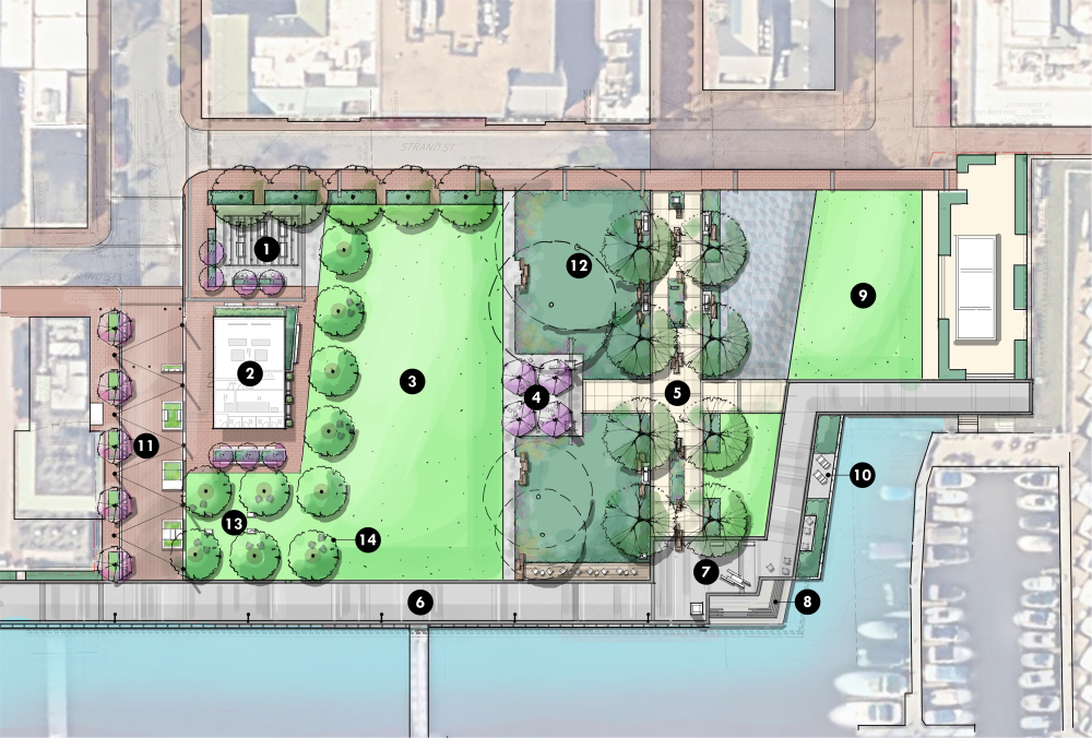
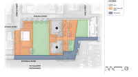
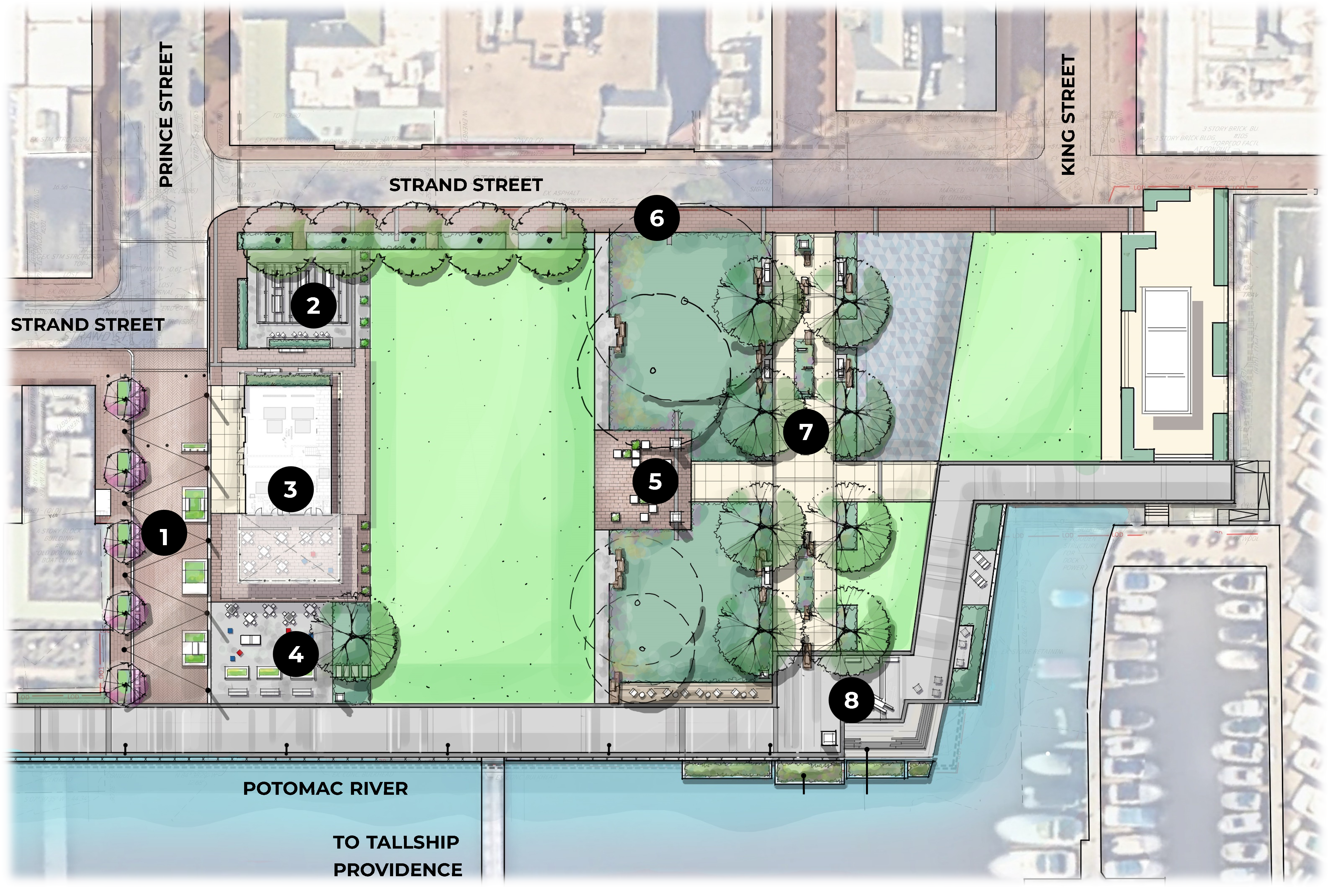
DESCRIPTION:
The new site plan concept leverages the pump station’s smaller footprint to maximize landscape, lawn, and canopy. The pump station recedes to the background behind a grid of trees. Adirondack chairs, cornholes, and other movable games can be integrated under the tree canopy if desired.
LEGEND:
1. Trellis structure with picnic tables and catenary lighting
2. Pump station
3. Multi-use lawn
4. Arrival plaza with movable seating
5. Wales Alley River Gateway
6. Promenade
7. Promenade plaza with seating / art / signage
8. Waterfront steps / seat wall
9. N. Waterfront area - to be replaced in kind
10. Boatyard overlook
11. Pedestrianized Prince Street / plaza with catenary lighting
12. Preserved existing trees (understory to be determined with arborist)
13. Optional cornholes and/or other movable games
14. Optional Adirondack chairs
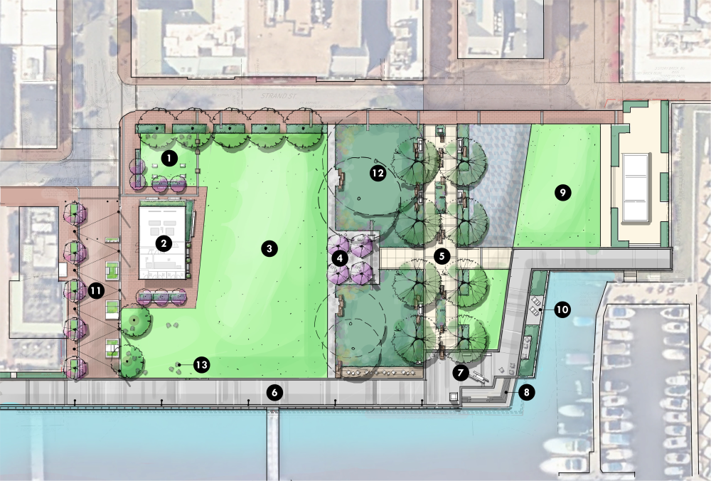
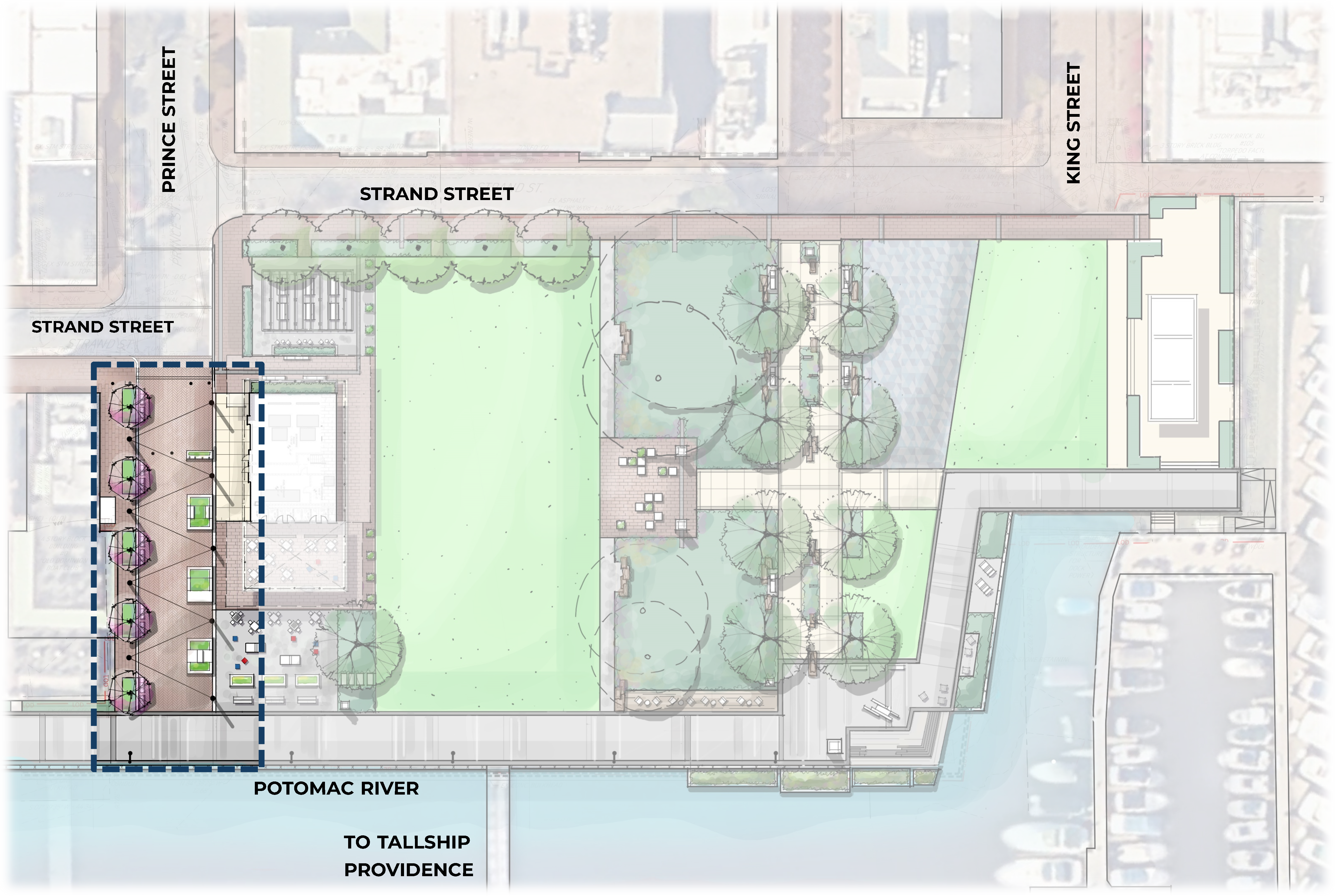
DESCRIPTION:
Option 2B removes the shade structure and picnic area west of the pump station to provide maximum programmable green space.
LEGEND:
1. Passive green space or programmable game lawn with cornholes, seat walls, and sliding wood crate seating
2. Pump station
3. Multi-use lawn
4. Arrival plaza with movable seating
5. Wales Alley River Gateway
6. Promenade
7. Promenade plaza with seating / art / signage
8. Waterfront steps / seat wall
9. N. Waterfront area - to be replaced in kind
10. Boatyard overlook
11. Pedestrianized Prince Street / plaza with catenary lighting
12. Preserved existing trees (understory to be determined with arborist)
13. Optional Adirondack chairs
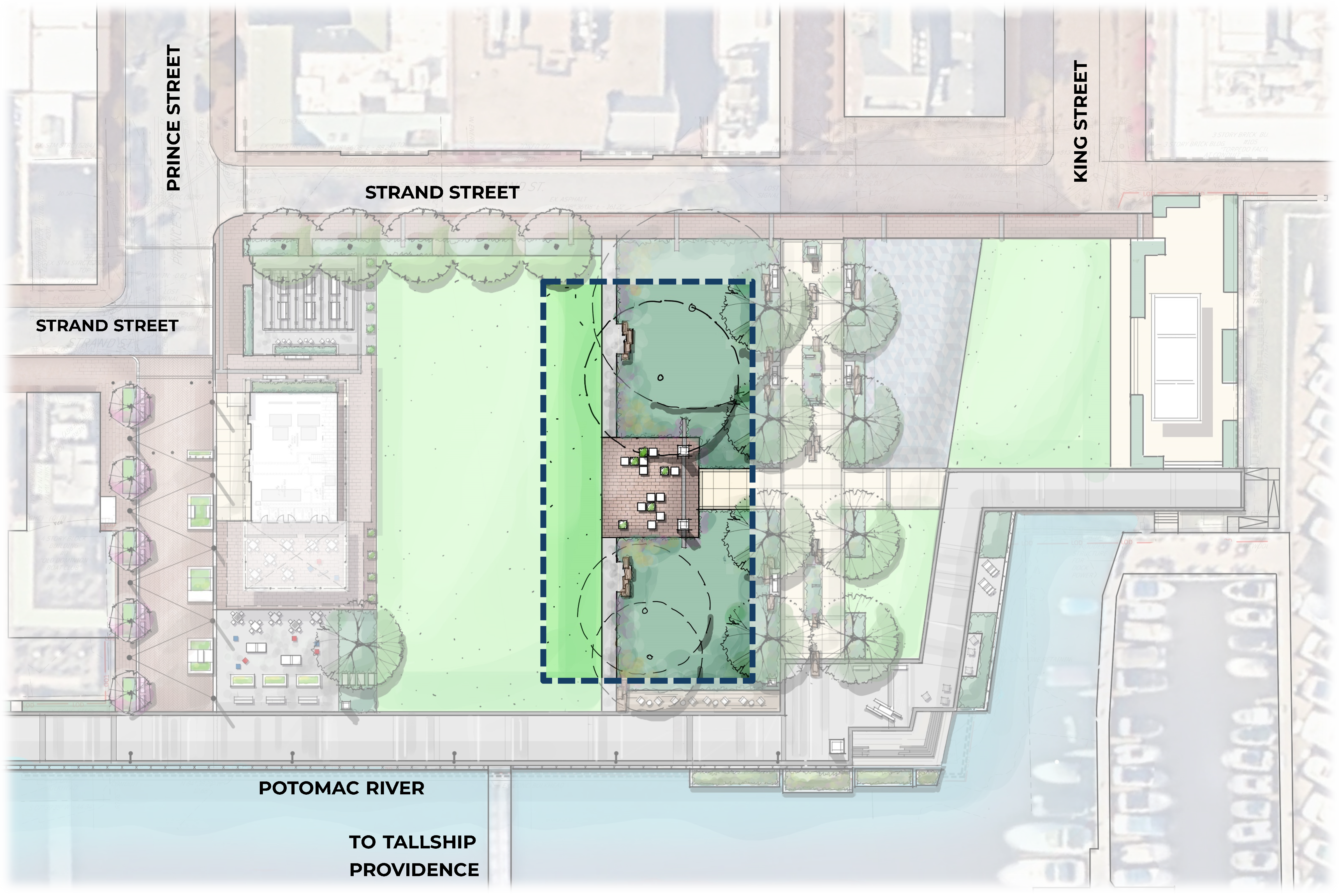
Waterfront Park Improvements
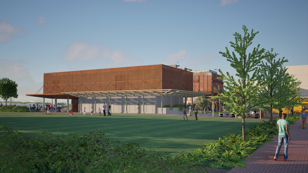
The following images are artist renderings depicting proposed improvements to Waterfront Park as of Spring 2025. The renderings and design concepts presented are currently under development, for conceptual reference only, and subject to change and design progresses. Additional information about current conditions and proposed design elements can be found in the sections below.

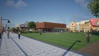

View of Waterfront Park from the intersection of King Street and Strand Street
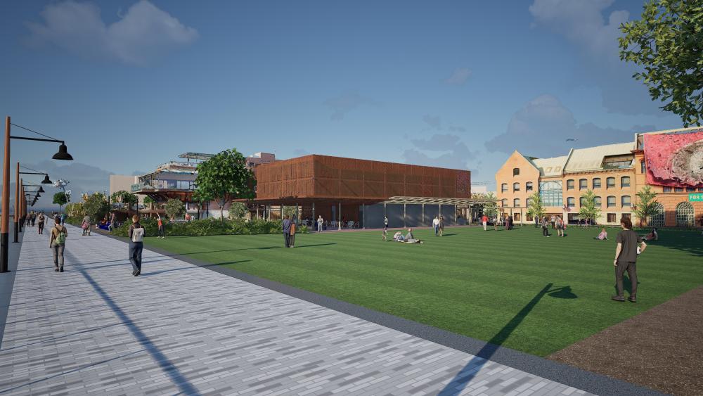
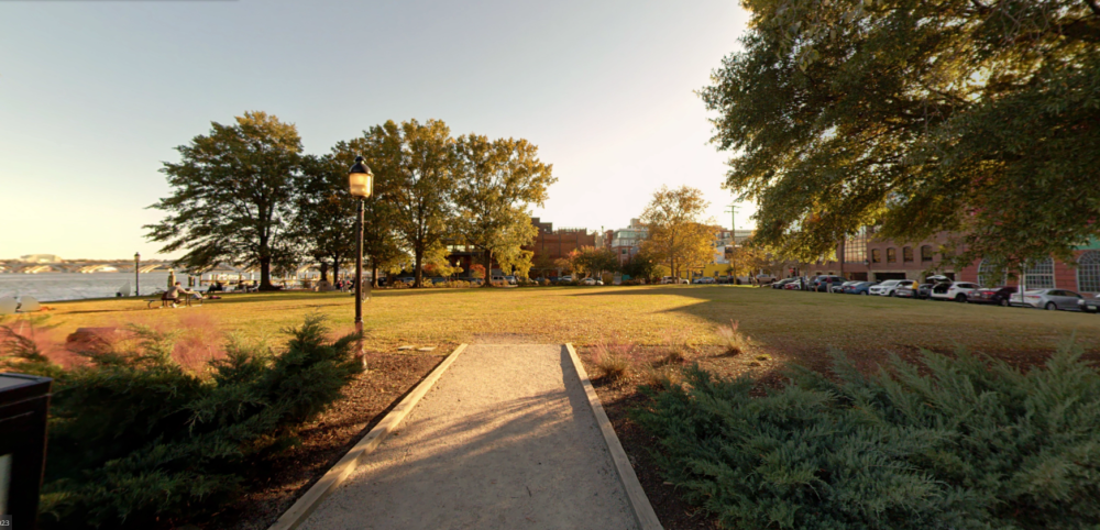
View of Waterfront Park from the northeast promenade.
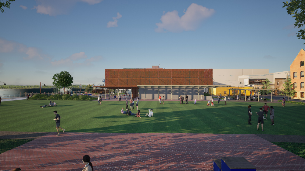
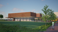
Daytime view of Waterfront Park and the Pump Station from the walkway on the north side of Waterfront Park.
View of the Pump Station and western Waterfront Park from the Strand Street at Old Dominion Boat Club.
View of the Pump Station and Waterfront Park from the current parking strip on Strand Street.

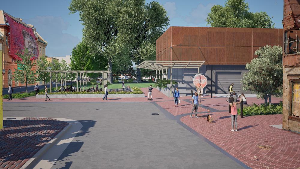
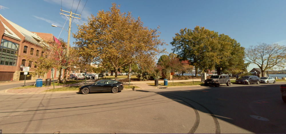
View of the Pump Station and Prince Street Plaza from the intersection of Prince Street and Strand Street.
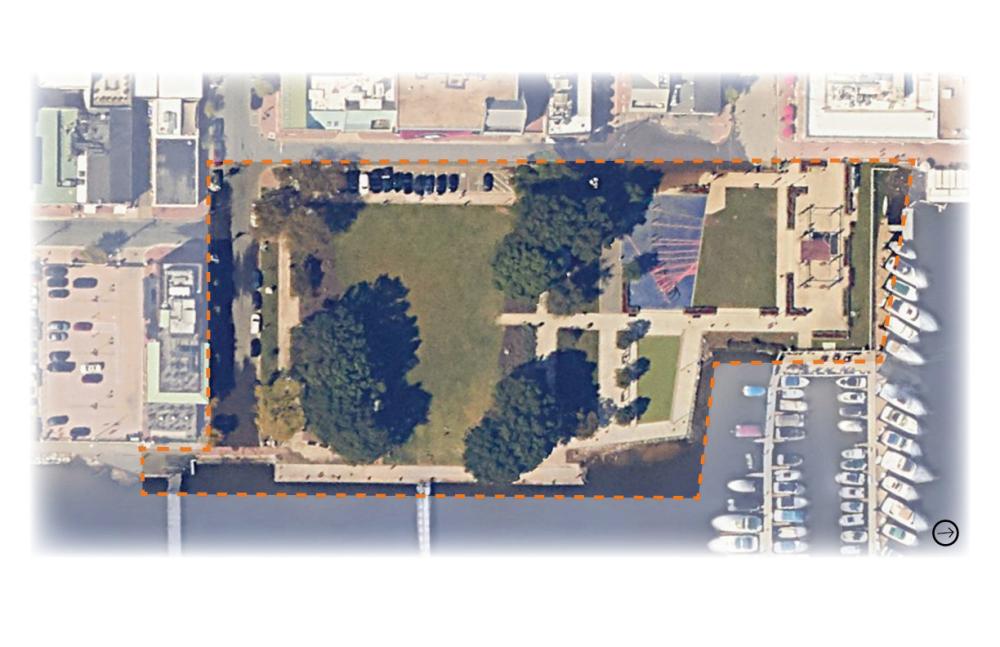
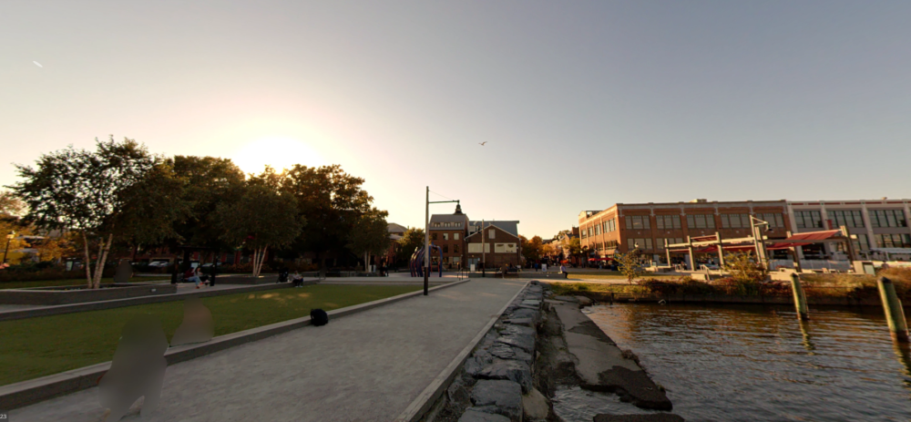
Existing Conditions
Site Location
Waterfront Park is located east of Strand Street, bordered by Wales Alley to the north and Prince Street to the south. King Street Park also sits east of Strand Street, but sits immediately north of Waterfront Park and Wales Alley, and south of the Torpedo Factory marina.
Site History
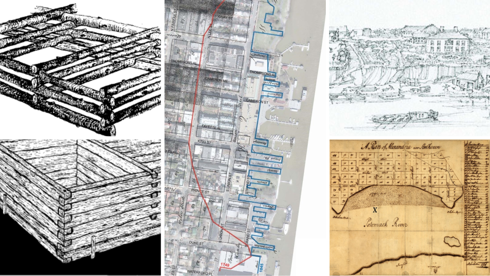
At the time of Alexandria’s founding, the area now known as Waterfront Park was marshland along the Potomac River. By the early the 19th century, waterfront areas in the city were dominated by industrial and warehouse uses. The area between King Street and Prince Street was no exception to this. Around this time a series of wharves appeared, projecting from these warehouses to the river. By the early part of the 20th century, many of the wharves had been removed or consolidated and this area of the waterfront fell into disrepair. By 1957, much of the area of the current park had been infilled and was used for commercial storage and light industrial functions. The City of Alexandria began acquiring waterfront property in 1977 and the area later became the current Waterfront Park. (Adapted from the Staff Report for BAR#2025-00172, dated June 5, 2025)
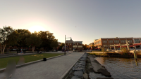


Looking west at King Street Park, King Street, and Strand Street from the waterfront promenade just north of the Wales Alley/River Gateway.
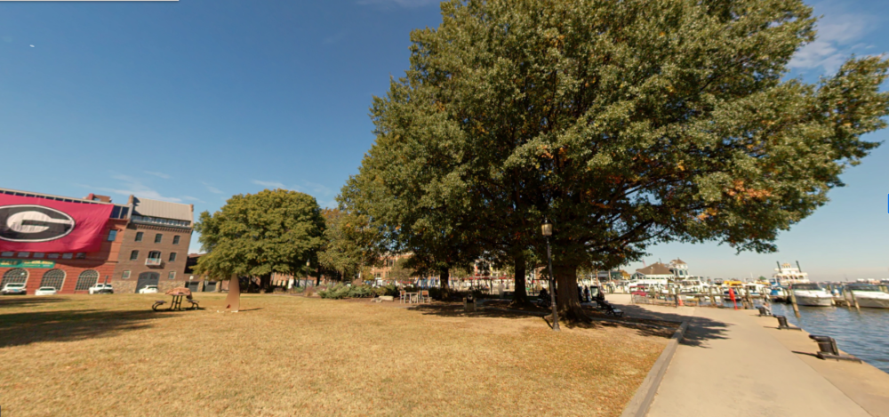
Looking north at Waterfront Park and shoreline from the promenade at the Tallship Providence pier entrance.
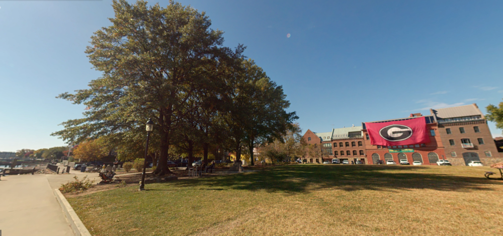
Looking west at Waterfront Park and Strand Street from the promenade at the Tallship Providence pier entrance.
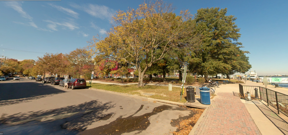
Looking north at Waterfront Park and Prince Street from the promenade at the foot of Prince Street.
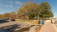
Looking north at Waterfront Park across Prince Street.
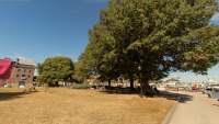
Looking south at Waterfront Park and Prince Street from the mid-park path from King Street Park.
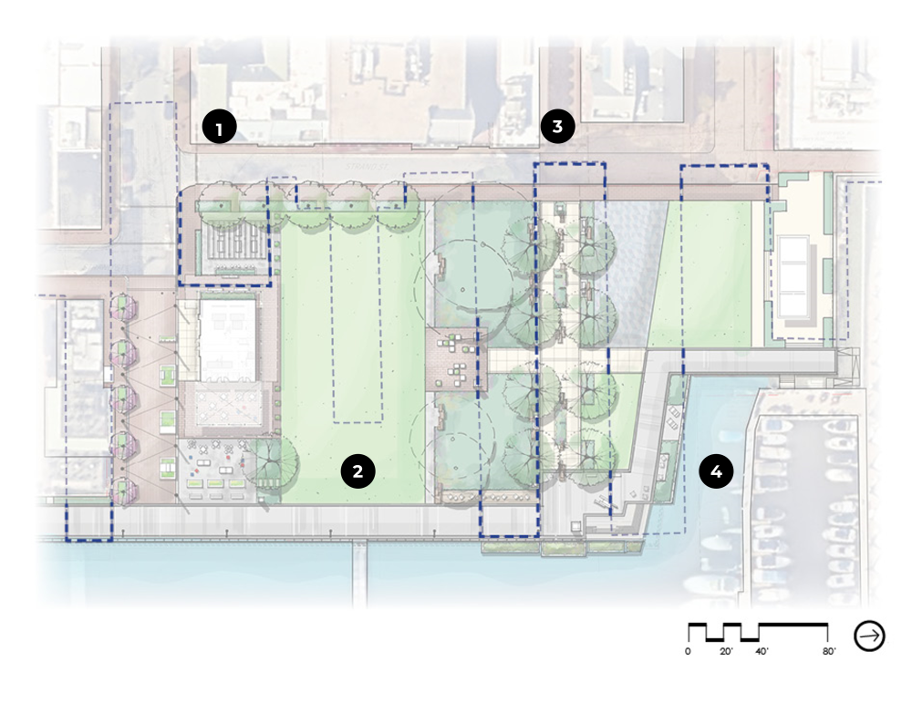
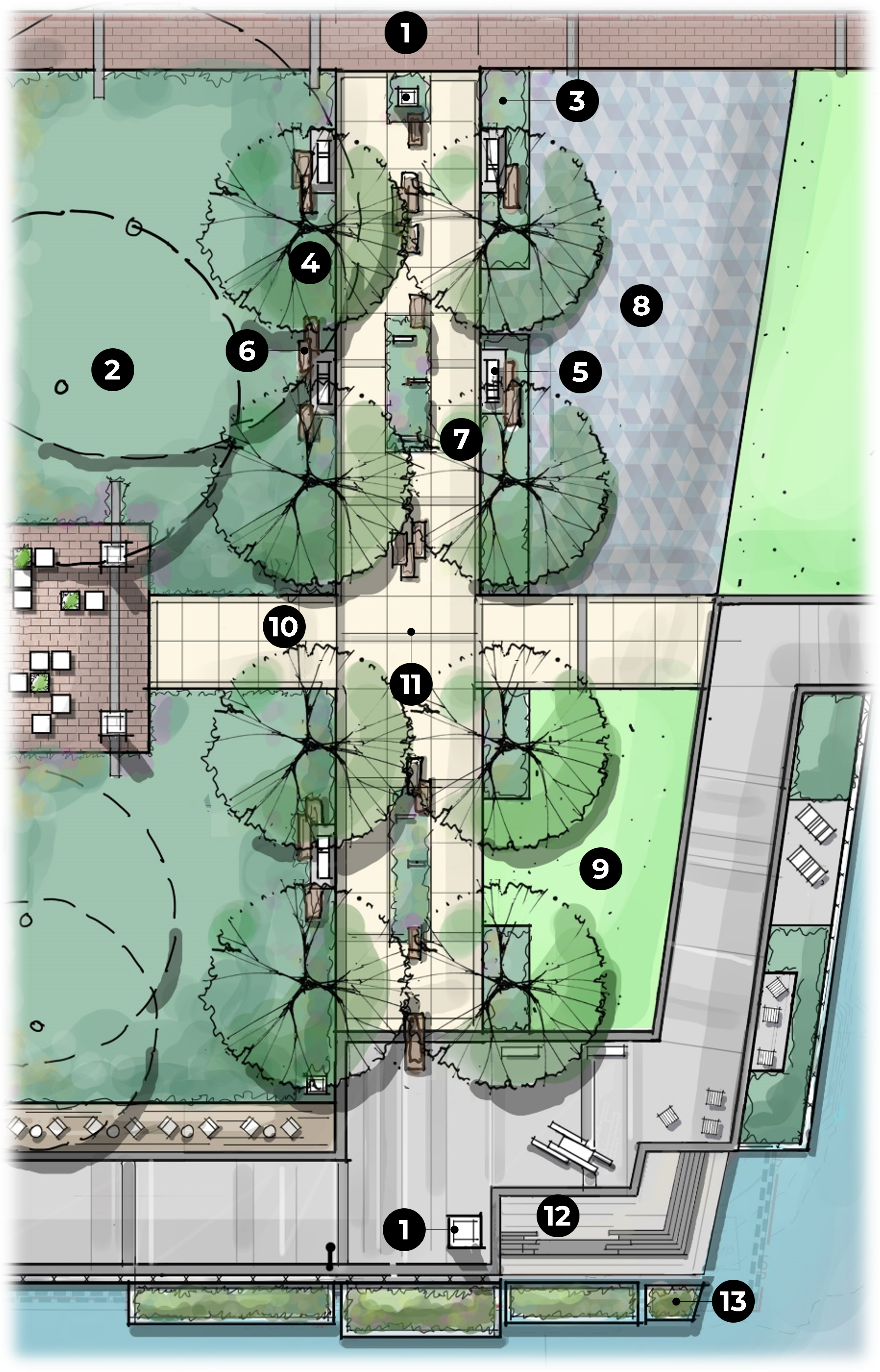
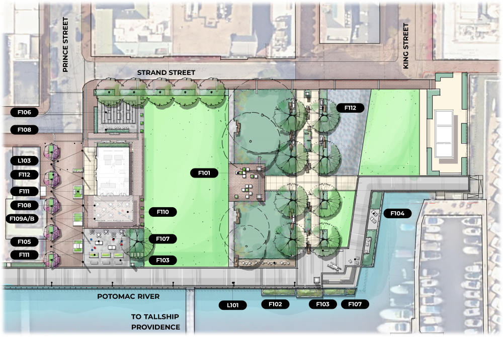
Proposed Plan
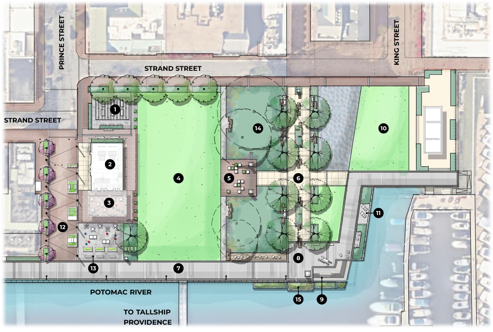

LEGEND:
1. Trellis structure with picnic tables and catenary lighting
2. Pump station
3. Covered plaza / venue space
4. Multi-use lawn
5. Arrival plaza with crate-inspired seating
6. Wales Alley River Gateway
7. Promenade
8. Promenade plaza with seating / art / signage
9. Waterfront steps / seat wall
10. N. Waterfront area - to be replaced in kind
11. Boatyard overlook
12. Pedestrianized Prince Street / plaza with catenary lighting
13. Flexible game / waterfront seating space
14. Preserved existing trees (understory to be determined with arborist)
15. Floating wetlands attached to bulkhead
LEGEND:
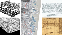
Left (top and bottom): The “cobb” and “crib” methods of wharf construction.
Middle: Alexandria’s historic shorelines in 1749 (red) and 1845 (blue)
Right (top): Conjectural drawing of Alexandria in 1763 (Elizabeth Luallen for Alexandria Archaeology Museum)
Right (bottom): The original Alexandria shoreline and town layout. As of its founding in 1749, the town was situated on 15-20’-height cliffs above a crescent-shaped bay between two projecting headlands.

LEGEND:
1. At-grade planting and movable raised planters along Prince Street reduce carbon dioxide and add “green” to the streetscape.
2. A raised bioretention planter captures roof runoff for infiltration and to reduce overall site runoff volumes and rates.
3. Decomposed granite paving in select program and circulation areas will create a permeable hardscape surface that slows runoff rates and increases infiltration, benefitting Potomac River water quality and habitats.
4. Lawn and planted areas will slow, clean, and infiltrate runoff; all could help to enhance river water quality. Preserved existing trees maintain the site’s landscape character, provide habitat, and absorb carbon dioxide.
5. Adaptively reused canal stones not only add to the sense of place, but also conserve resources.
6. Planting buffer along this edge provides infiltration and treatment opportunities. Decks engage the waterfront and offer opportunities for informative educational signage.
7. Steps to the water engage the Potomac River waterfront in a new way.
8. Due to dredging along the Potomac shoreline (8’ deep, +/-), living shoreline cannot be accommodated along this west edge, but floating wetlands could potentially be attached to the bulkhead. These would provide habitat and promote improved water quality, plus provide educational opportunities with signage.
LEGEND:
1. Blue dashed lines indicate where paving bands can delineate the historic 1845 shoreline to represent the “banking out” process in the ground plane.
2. The approximate historic shoreline layout is shown in gray. To maintain the lawn’s potential for programming and recreational usage, the historic shoreline is not expressed here to avoid tripping hazards and other safety concerns.
3. The “River Gateway” is one of the few places throughout the waterfront where a full segment of historic 1845 shoreline can be traced in hardscape. The Gateway will introduce the concept of representing the historic shoreline in paving using a band – a feature already used throughout the waterfront’s existing spaces and streetscapes – to give the detail even more meaning and significance. Supplemental timeline signage will further convey the story of the shoreline’s evolution.
4. Interpretive signage at observation decks along the waterfront can tell the story of the modern shoreline’s incorporation of flood resiliency, habitat creation, and sustainability. The shoreline is being reshaped again, but this time for a different purpose.
LEGEND:
1. Lawn or hardscape cannot be proposed in these areas due to preservation of existing trees. Disturbance to the trees’ critical root zones (dashed) must be kept at a minimum to promote tree survival.
NOTE: Lawn and hardscape square footage calculations are approximate and conceptual in nature. Existing areas are based on current site survey and aerial information. Proposed areas are based on hand-drawn concept plan and subject to change as the design progresses.
PROGRAMMABLE LAWN COMPARISON
EXISTING CONDITION: ~28,000 SF
PROPOSED CONDITION: ~20,000 SF
NET CHANGE: ~7,000 SF loss
OPEN SPACE COMPARISON
EXISTING CONDITION: ~32,000 SF
PROPOSED CONDITION: ~39,500 SF
NET CHANGE: 7,500 SF gain (4,000 SF = Prince Street)
PUMP STATION BUILDING COMPARISON
ORIGINAL OVERALL BUILDING AREA: 8,065 SF TOTAL
CURRENT OVERALL BUILDING AREA: 5,285 SF TOTAL
CHANGE IN OVERALL BUILDING AREA: 2,780 SF Reduction
ORIGINAL PROPOSED FOOTPRINT (ground level only): 4,035 SF (ground level only)
CURRENT PROPOSED FOOTPRINT (ground level only): 2,250 SF (ground level only)
NET CHANGE (ground level only): 1,785 SF Reduction
Plan Features
LEGEND
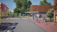
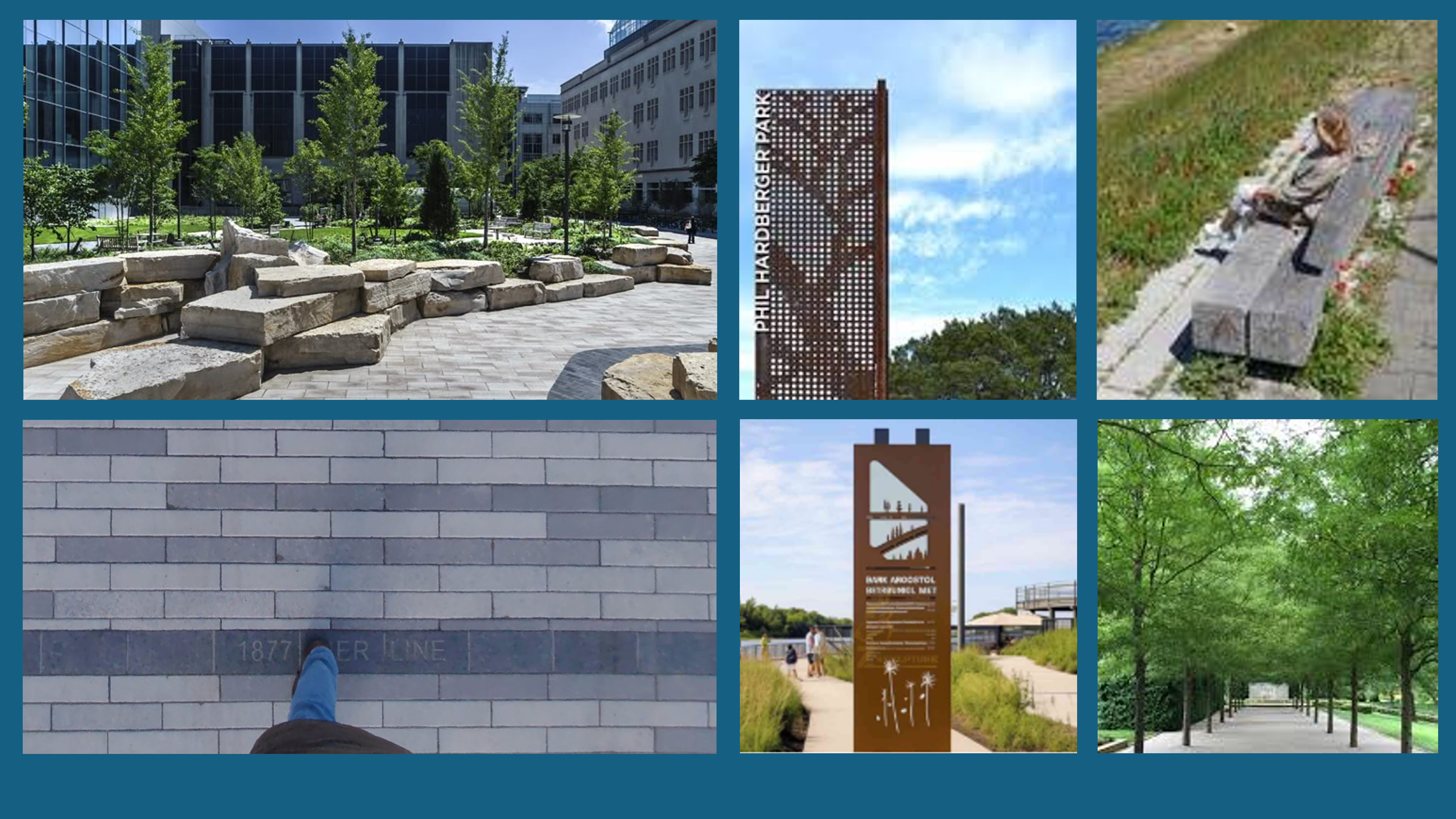
About the Prince Street Pedestrian Plaza
Shipyard and cribbing-inspired furnishings in the waterfront game space and Prince Street festival plaza/streetscape celebrate the park’s connection to the water and its historic context. Brick paving materials along Prince tie existing to proposed.
Prince Street Pedestrian Plaza Design Features
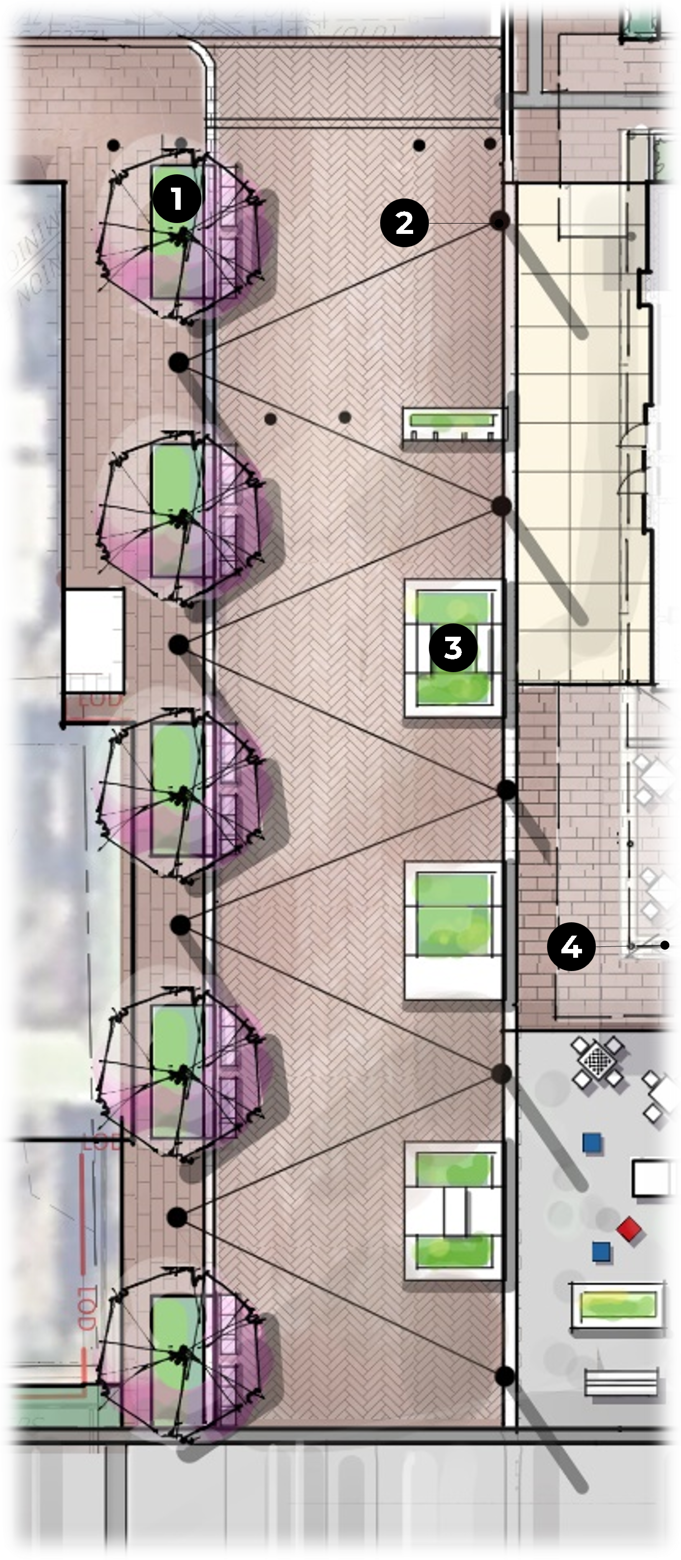
LEGEND
- In-ground planters + benches
- Poles with catenary lighting
- Movable planters with seating
- Covered plaza / venue space with movable tables and chair
Prince Street Pedestrian Plaza Design Inspiration


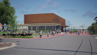
About the West (Strand Street) Plaza
A shade pergola in this outdoor dining area will emulate the character of the pump station, with nods to ship and wharf construction.
West (Strand Street) Plaza Design Features
LEGEND
- Trellis with catenary lighting; columns to align with pump station building canopy grid
- Picnic tables
- Raised bioretention planter
- Pump station
- Pump station canopy
- Raised planting areas
- Planting areas at grade
- Seating along planter walls
- Historic 1845 shoreline banding
- Stage / performance area
West (Strand Street) Plaza Design Inspiration


About the Pump Station
An artful metal facade as an homage to the Potomac River watershed will transform the pump station into “art in the park” and reinforce the River-inspired story. Its integrated covered plaza will provide flexible seating, games, and programmable event space – making the pump station itself a key park feature that enhances the user experience.

About the East (Riverfront) Plaza
Shipyard and cribbing-inspired furnishings in the waterfront game space and Prince Street festival plaza/streetscape celebrate the park’s connection to the water and its historic context. Brick paving materials along Prince tie existing to proposed.
East (Riverfront) Plaza Features
LEGEND
- Covered plaza / venue space with movable tables and chairs
- Hammocks / swing attached to canopy (removable for events
- Poles with catenary lighting
- Pump Station
- Ping pong tables
- Specialty double-sided promenade seating
- Movable planters with seating
East (Riverfront) Plaza Design Inspiration
About the Arrival Plaza
The park’s arrival plaza and garden walkway could incorporate stacked canal stones from the excavated Alexandria Canal, as well as playful seat cubes inspired by cribbing construction.
Arrival Plaza Features
LEGEND
- Cube seating
- Existing trees to be preserved and planting areas to be enhanced
- Signature 1845 shoreline granite band
- Stacked canal stones
- Multi-use Lawn

About the Strand Street Walkway
The Strand Street Walkway will use brick and granite banding to link with Old Town and trace the 1845 shoreline.
Strand Street Walkway Features
LEGEND
- Existing trees to be preserved and planting areas to be enhanced
- Pedestrian streetscape brick pavers
- New at-grade planting areas
- Signature 1845 shoreline granite band
- Rotating art display (to be replaced in-kind)
- Planting areas at grade
- Synthetic turf (to be replaced in-kind)

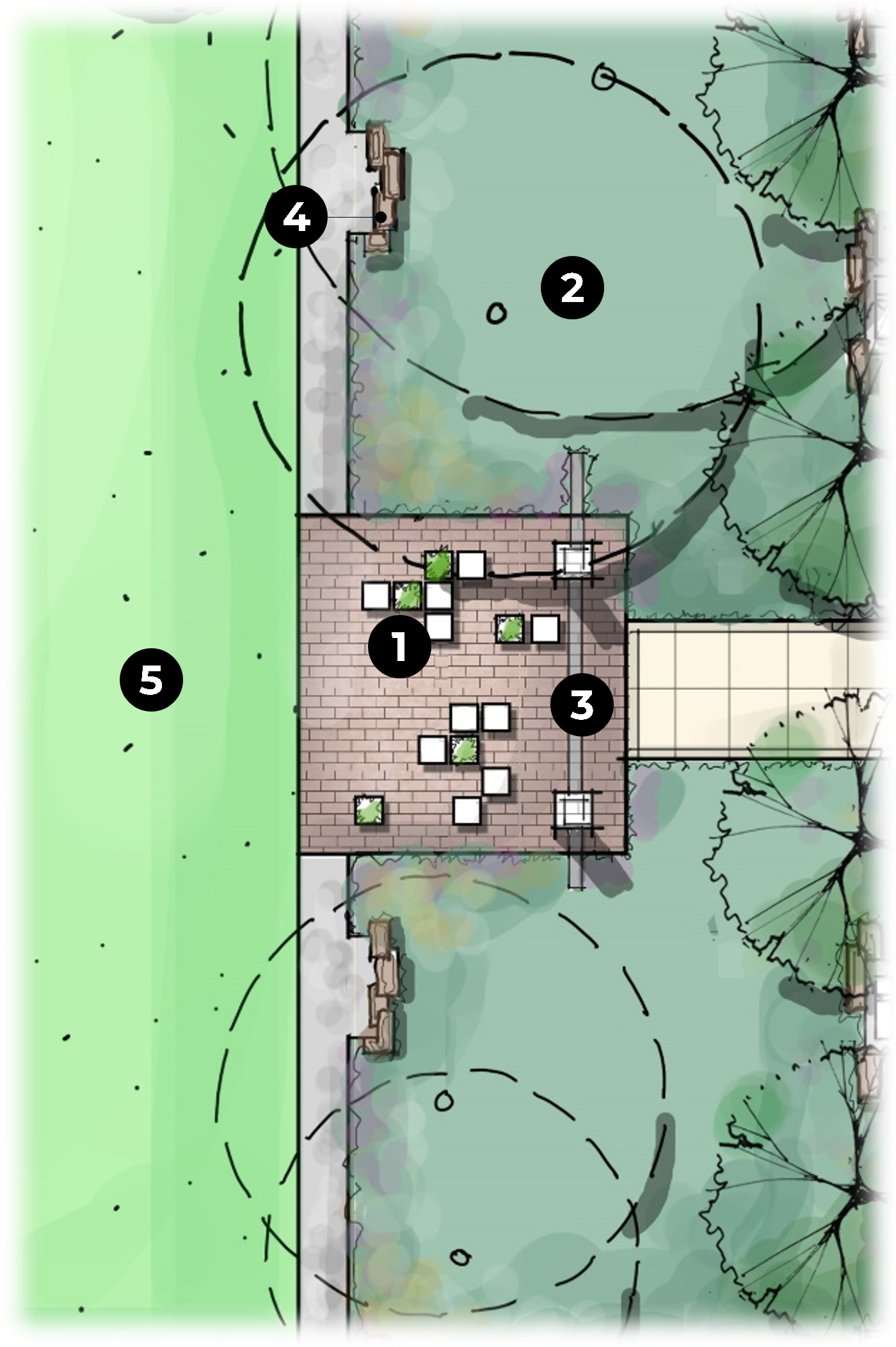
About the Wales Alley River Gateway
The Wales Alley River Gateway will anchor the park's river narrative with timeline signage, specialty paving, and artifacts that trace Alexandria's "banking out" trade history from Old Town to the modern waterfront.
Wales Alley River Gateway Features
LEGEND
- Gateway branding/signage column
- Existing trees to be preserved and planting areas to be enhanced
- New at-grade planting areas
- Tree allee
- Timber benches evoking historic cribbing
- Stacked canal stones
- Informational signage in planting areas describing shoreline evolution/banking out
- Rotating art display (to be replaced in-kind)
- Synthetic turn (to be replaced in-kind)
- Signature 1845 shoreline granite band
- Timeline paving concrete band
- Waterfront plaza and steps/seated wall
- Opportunity for floating wetlands at bulkhead
Wales Alley River Gateway Design Inspiration

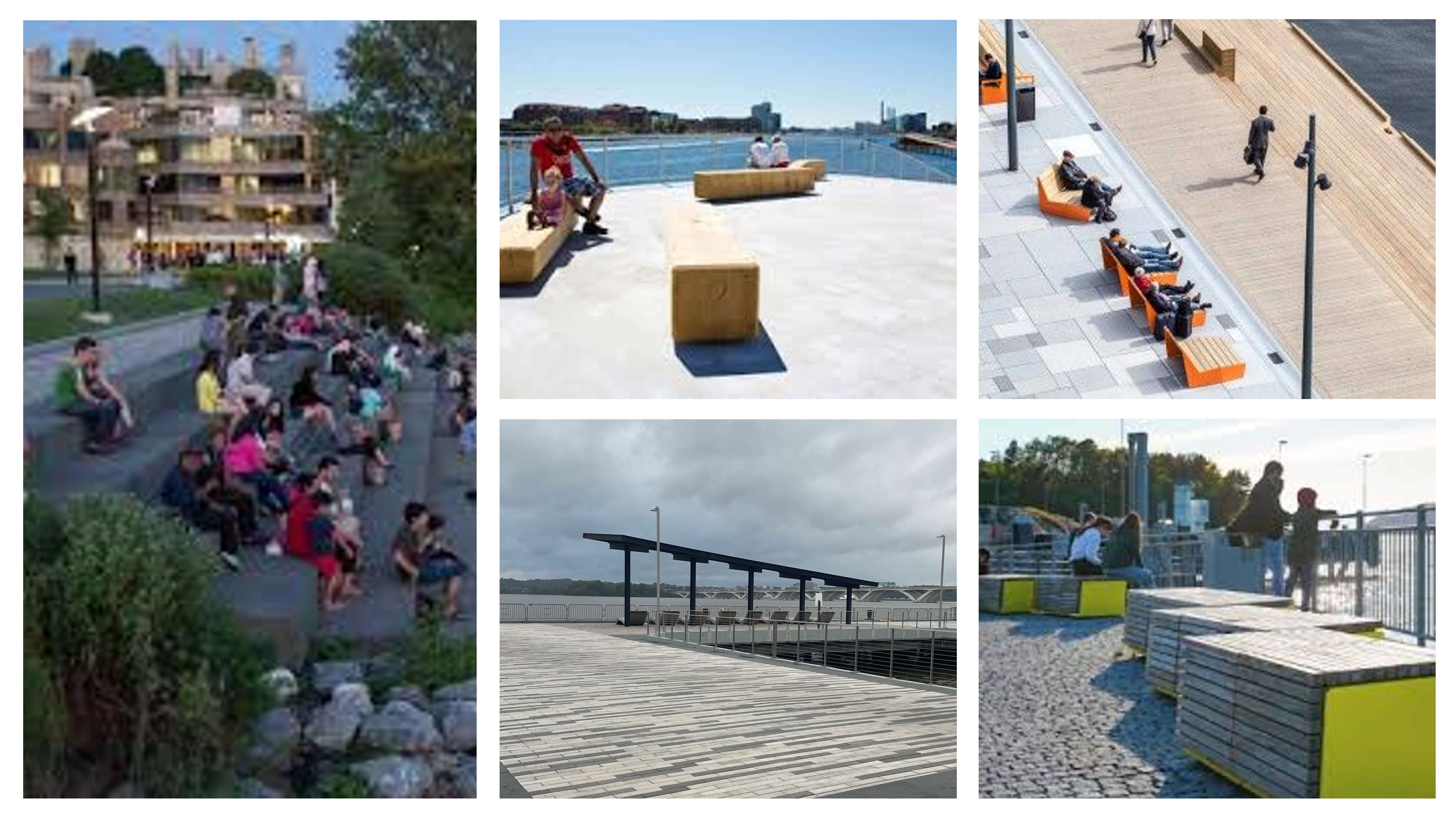
About the Waterfront Promenade and Bulkhead
Waterfront Promenade and Bulkhead Features

LEGEND
- Historic artifact or sculptural seating
- Timber bench with canal stones behind
- Canal stone seating
- Promenade lounge seating
- Overlook with signage/art/branding
- Waterfront plaza and steps/seat wall
- Wales Alley River Gateway
- Opportunity for floating wetlands at bulkhead
Waterfront Promenade and Bulkhead Design Inspiration
Site Sections
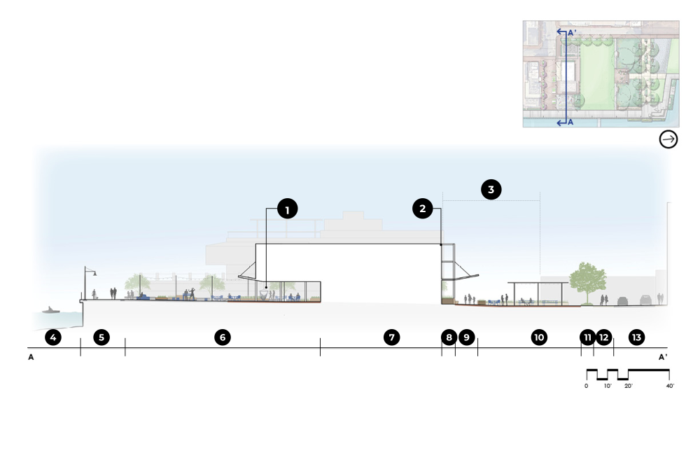
Cross Section: Promenade, East Plaza, Pump Station, and West Plaza
LEGEND:
1. Ship-inspired Hammock/Swing Seating Under Canopy
2. Pump Station Building Edge Aligned with Old Dominion Boat Club
3. S. Strand Street Alignment
4. Potomac River
5. Promenade
6. Pump Station Plaza with Games and Seating
7. Pump Station
8. Bioretention Planter
9. Walkway with Seating
10. Plaza with Trellis Structure
11. Planting
12. Sidewalk
13. Strand Street
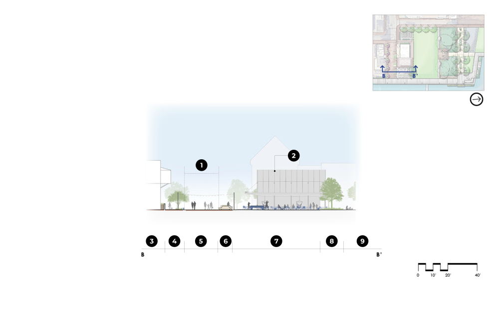
Cross Section: Prince Street Plaza and Pump Station
LEGEND:
1. Prince Street
2. Pump Station with Covered Plaza/Venue Space and Restrooms
3. Old Dominion Boat Club
4. Sidewalk
5. Street End Plaza
6. Movable Planter Seating
7. Plaza with Games and Furnishings
8. Planting
9. Multi-purpose Lawn
Materials and Furnishings
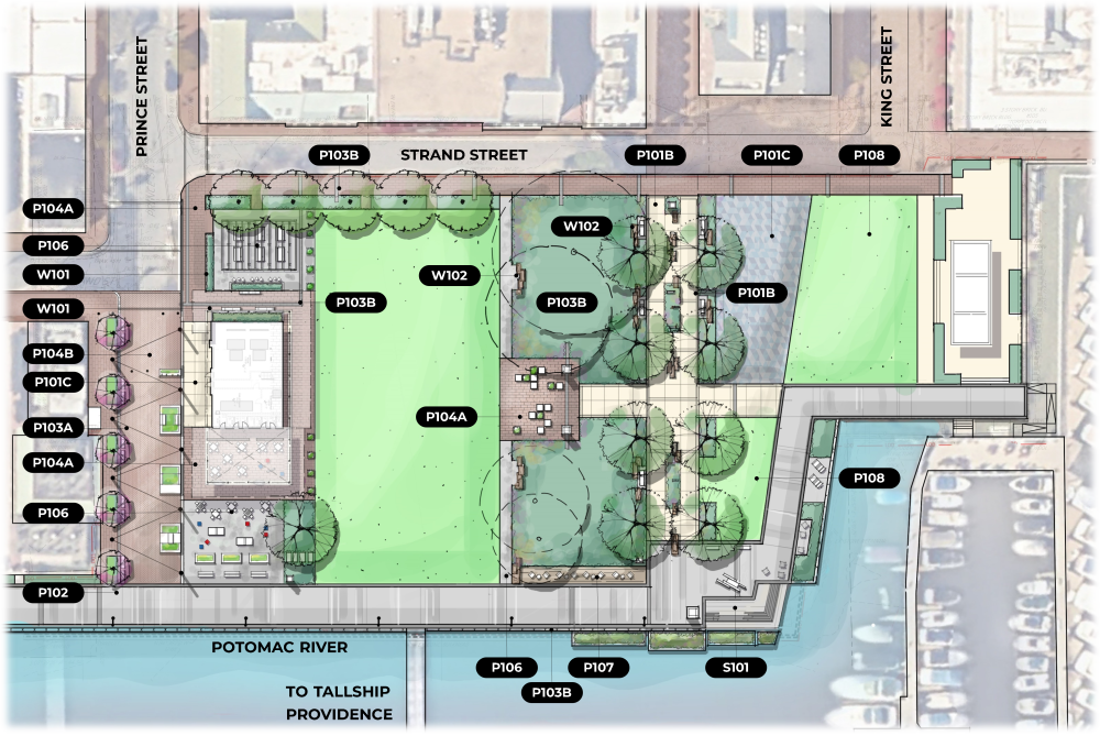


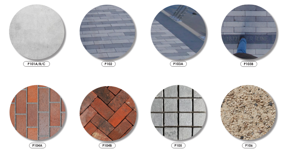
LEGEND:
P101a: Poured in Place Concrete Type 1: Pedestrian Grade Concrete Paving
P101b: Concrete Band: Varies Between Pedestrian and Vehicular Grade
P101c: Poured in Place Concrete Type 2: Vehicular Grade Concrete Paving
P102: Concrete Pavers: Promenade Paving to Match Robinson Landing
P103a: Granite Band Type 1: Promenade Banding
P103b: Granite Band Type 2: Text-Inscribed Band Granite Paver
P104a: Brick Pavers Type 1: Streetscape Sidewalk Pedestrian-Grade
P104b: Brick Pavers Type 2 Streetscape Sidewalk Vehicular-Grade
P105: Cobble Stones: Alternative to Vehicular-Grade Concrete
P106: Stabilized Granite Pathway: Kafka Granite, Organic Loc, or Similar
P107: Wood Decking: Sustainably Sourced Wood or Simulated Deck Material
P108: Synthetic Turf: Replace in Kind at North Waterfront
W101: Wall Type 1: Planter Walls
W102: Wall Type 2: Stacked Canal Stones
S101: Stair Type 1: Stone Steps and Integral Seat Wall
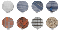
LEGEND:
P101A/B/C: Concrete Type 1, 2, And Band Varies Between Pedestrian and Vehicular Grade
P102: Concrete Pavers: Promenade Paving to Match Robinson Landing
P103A: Granite Band Type 1: Promenade Banding Granite Paver
P103B: Granite Band Type 2: Text-Inscribed Band Granite Paver
P104A: Brick Pavers Type 1 Alexandria Standard Brick – Running Bond Pattern – Full Range of Color – Pedestrian-Grade
P104B: Brick Pavers Type 2: Alexandria Standard Brick – Herringbone Pattern – Full Range of Color – Vehicular-Grade
P105: Cobble Stones: Prince Streetscape Alternative at Pump Station
P106: Stabilized Granite Pathway: Kafka Granite, Organic Loc, or Similar
*Note: All Paving In E.V.E. To Be Vehicular-Rated.
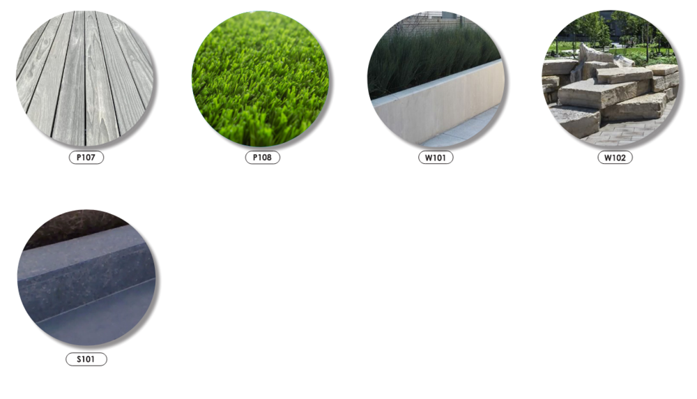
LEGEND:
P107: Wood Decking: Sustainably Sourced Wood or Simulated Deck Material
P108: Synthetic Turf: Replace in Kind at North Waterfront
W101: Wall Type 1: Concrete Planter Walls
W102: Wall Type 2: Stacked Canal Stones
S101: Stair Type 1: Granite Steps to Match Promenade Banding
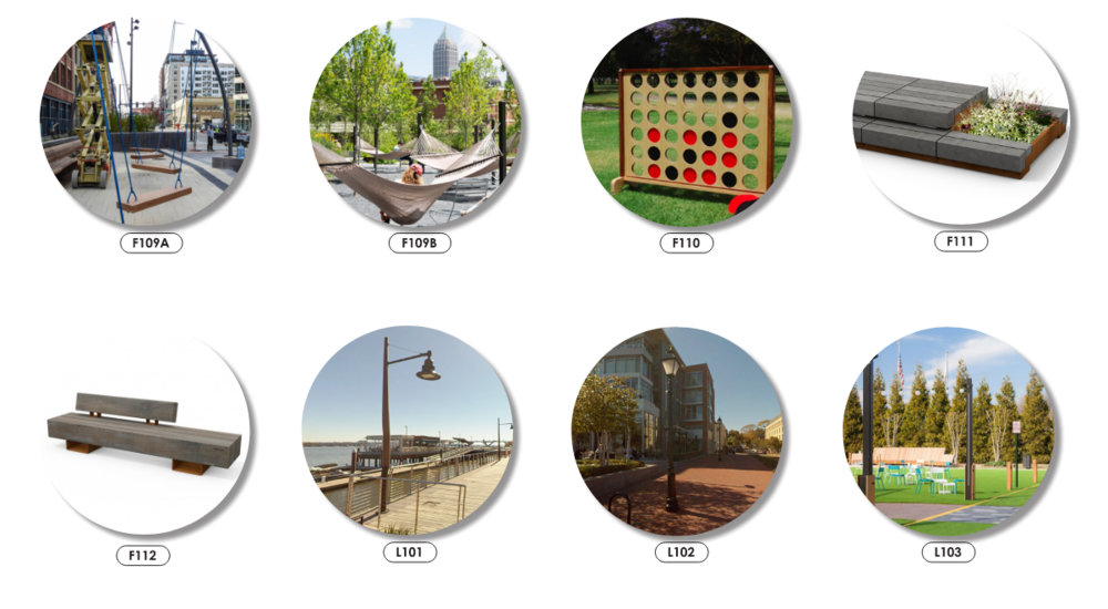
LEGEND:
F101: Square Modular Bench With Integral Planters
F102: Chunky Wood Chaise Lounge And Table
F103: Plaza Benches
F104: Lounge Chair
F105: Ping Pong Table
F106: Picnic Tables
F107: Movable Cube
F108: Movable Tables/Chairs (Four Top And Two Top)
F109a/B: Hammock/Swing Seating
F110: Movable Games
F111: Heavy Duty Movable Planters
F112: Streetscape Benches
L101: Pole Light Type 1: Promenade Nautical
L102: Pole Light Type 2: Street Light Alexandria Standard
L103: Catenary Lighting

LEGEND:
F101: Square Modular Bench With Integral Planters (Color TBD)
F102: Chunky Wood Chaise Lounge And Table (Color TBD)
F103: Plaza Benches (Color TBD)
F104: Lounge Chair (Color TBD)
F105: Ping Pong Table (Color TBD)
F106: Picnic Tables (Color TBD)
F107: Movable Cube (Color TBD)
F108: Movable Tables/Chairs (Four Top And Two Top) (Color TBD)
LEGEND:
F109A: Hammock/Swing Seating Option 1 (Color TBD)
F109B: Hammock/Swing Seating Option 2 (Color TBD)
F110: Movable Games (Color TBD)
F111: Prince Street Planters (Color TBD)
F112: Prince Street Benches (Color TBD)
L101: Pole Light Type 1: Promenade Nautical
L102: Pole Light Type 2: Street Light Alexandria Standard
L103: Catenary Lighting (Custom)
Waterfront Park Design History
The following section documents the web content previously posted about the Waterfront Park Plan development.
Park and Bulkhead Improvements
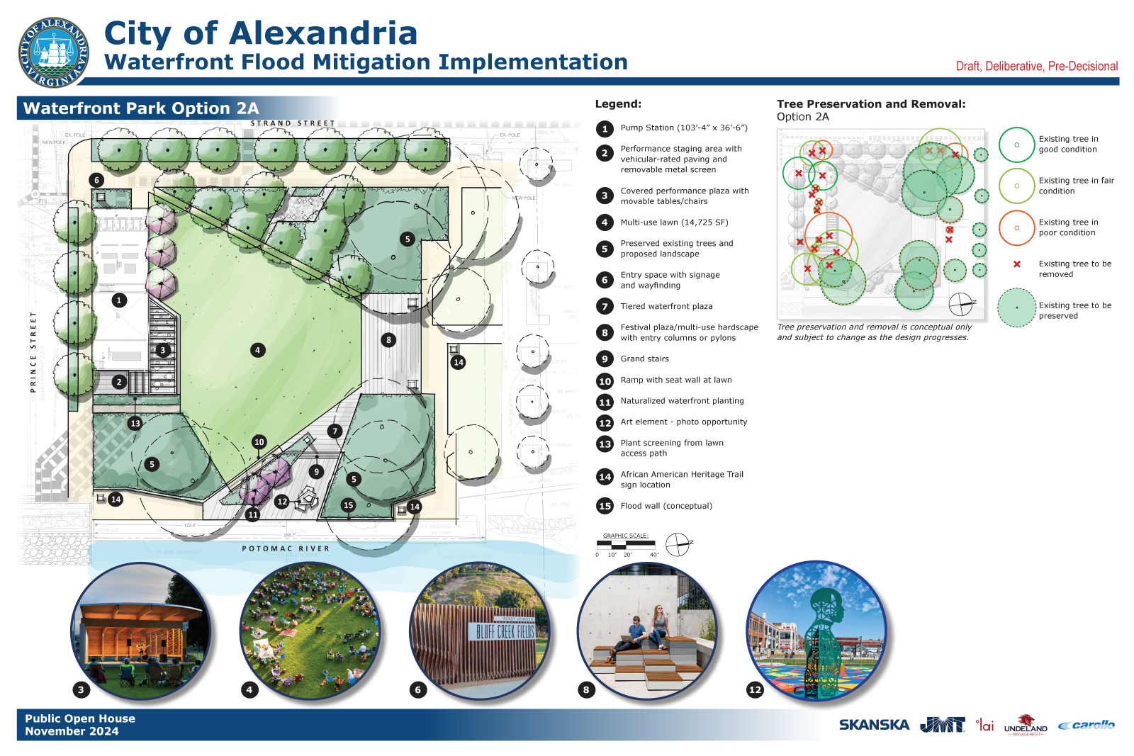
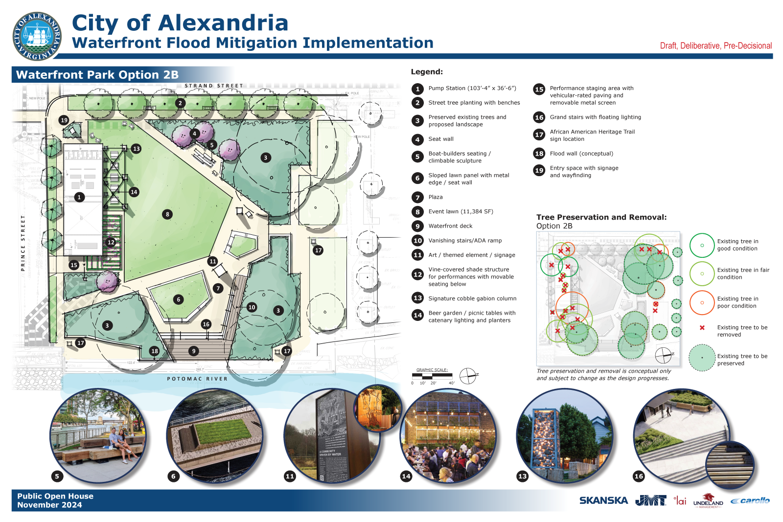
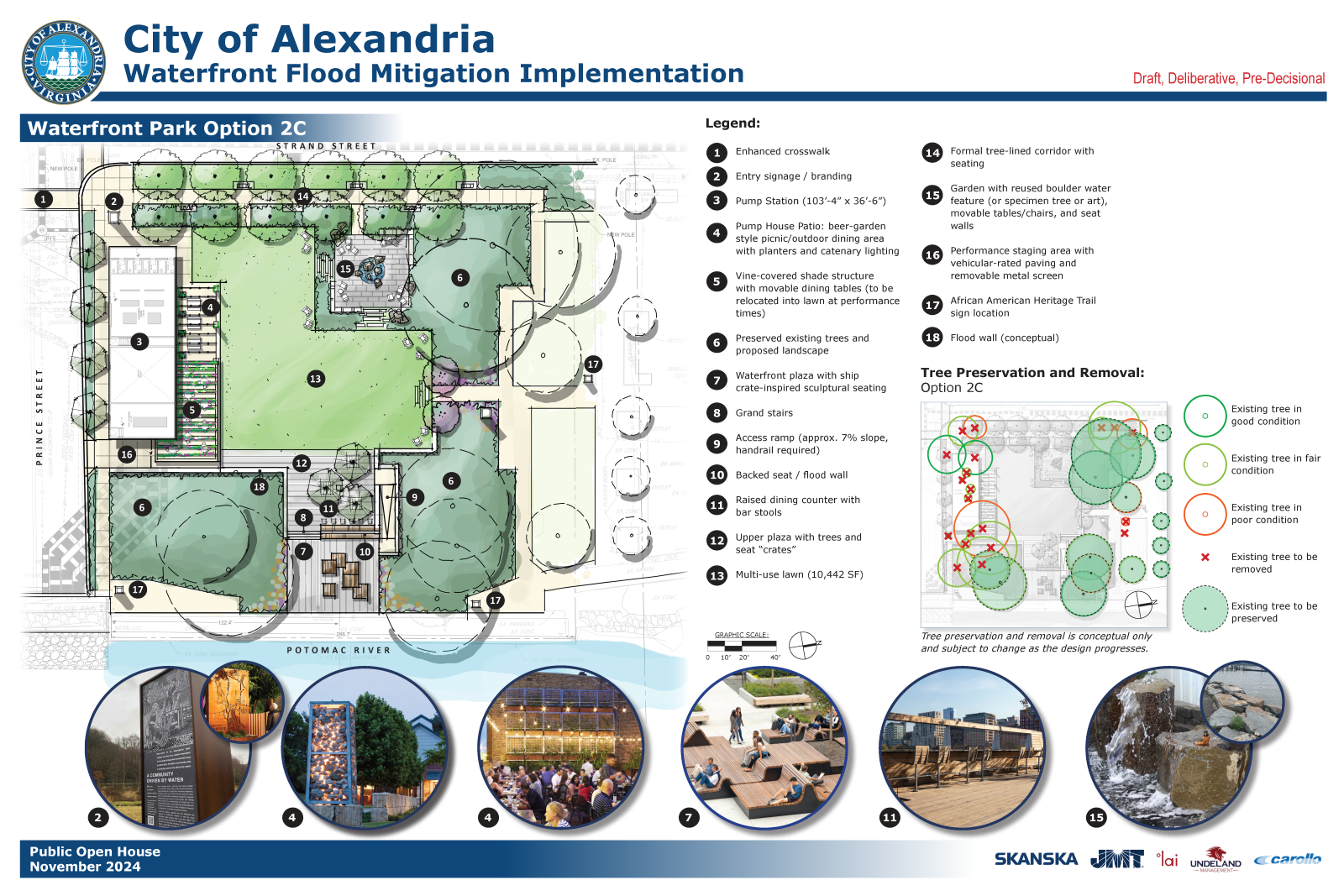
The following images illustrate examples of how amenities were being integrated into the landscape of Waterfront Park as of Fall 2024.
Strand Street Orientation
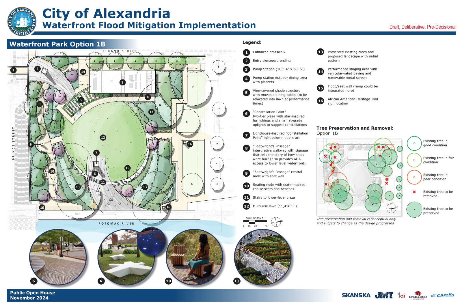
Prince Street Orientation
* All designs are drafts, deliberative, and pre-decisional. The determination of budget feasibility is based on cost estimates. Affordability will be evaluated based on ongoing design development/engineering, cost estimation, and risk assessments.