Project Purpose
This portion of King Street was identified for multimodal improvements in the City's 2021 adopted Alexandria Mobility Plan and is a priority location to install enhanced bicycle facilities and additional sidewalks to complete gaps in the City's existing bicycle and sidewalk network. Safety improvements along this corridor will help the City reach the Vision Zero goal of eliminating all fatal and severe crashes.
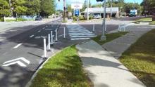
The project seeks to install an improved sidewalk, two-way cycle track, enhanced bus facilities and roadway improvements which address project goals and improve the safety and mobility of all roadway users.
A concept plan for the corridor was approved by the Traffic and Parking Board in June 2024 and City Council in October 2024 (see below for links to the presentations and a recording of the meetings). City Staff are working with a design team to take the approved concept through the full design process.
Corridor Safety Improvements
In advance of future project activity, City Staff is implementing short-term safety improvements within the study area to improve mobility, safety, and access for all roadway users of all ages, abilities and modes of travel. Stay tuned for additional updates!
March 2025: Speed Feedback Signs on King Street
Based on requests received from the community, the City installed two speed feedback signs on King Street, one facing eastbound and one facing westbound traffic. These signs improve road safety by alerting drivers to their speed in real-time, encouraging them to slow down and reduce the potential for crashes.
Photograph of recently installed speed feedback sign on King Street.
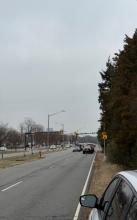
February 2025: Pedestrian Median Improvements at King and S. Taylor Streets
The City is installing flex posts around the raised pedestrian medians on the east side of the intersection of King Street at S. Taylor Street to improve safety by enhancing median visibility, increasing a buffer between pedestrians and vehicles, and slowing left-turning traffic.
Photograph of installed flex posts at pedestrian median.
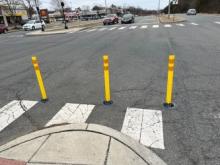
February 2025: Vehicle Guidelines at the Intersection of King and S. Taylor Streets
To assist vehicles navigating left turns through the intersection, the City is painting two pavement marking lines in the intersection to provide visual cues to help drivers stay in the correct lane while turning. Improved vehicle guidance will minimize confusion for drivers on the roadway.
Illustrative diagram indicating approximate locations of pavement marking lines (white curved lines) through intersection. February 2025: Curb Radii Tightening at the Intersections of King Street and S. Taylor and S. Wakefield Streets
The City is using pavement markings and flex posts to square the curb radius at King Street's intersections with S. Taylor and S. Wakefield Streets. This design slows turning vehicles, giving drivers more reaction time and enhancing safety for both pedestrians and vehicles. It also expands space for pedestrians and shortens the crossing distance at crosswalks for added safety.
Illustrative image showing the use of striping (paint) and flex posts to create a more square curb radius with more space for pedestrians.
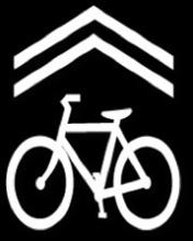
February 2025: Sharrows on the King Street Access Road and Marlee Way
The City is installing signage and symbol markings to designate the King Street Access Road, between Quaker Lane and Menokin Drive, and Marlee Way, as "sharrows" or lanes that are shared by both vehicles and bicycles. These interim improvements will remind drivers to expect cyclists on the roadway, making it safer for cyclists to share the lanes.
Installation of No Turn on Red Signs
At the intersections of N Dearing Street and King Street and S. Taylor Street and King Street, City Staff have ensured that all right turns have consistent "No Turn on Red" signs installed and the sign design is consistent. This included installing new signs and updating the design of older signs. Installing "No Turn on Red" signs increases pedestrian safety and decreases crashes at intersections.
Add Leading Pedestrian Intervals (LPIs) at Intersections
Where King Street intersects with Menokin Drive, N. Dearing Street and S. Taylor Street, LPIs have been added to the signal timing. Adding a LPI to the pedestrian signal request gives pedestrians a head start when crossing a street, allowing pedestrians to establish themselves in the intersections and cross more safely.
Project Boundaries
The Study Area consists of the King Street Corridor and parallel access road, from N. Quaker Lane in the east, to just north of Menokin Drive on the west. No design changes to the intersection of North Quaker Lane, King Street and West Braddock Road are being considered as part of this project.
Project Goals
The goals of this project are to:
- Improve mobility, safety, and access for all roadway users of all ages, abilities and modes of travel.
- Install safer pedestrian access and bicycle facilities which connect into the surrounding network.
- Improve existing stormwater treatment in the corridor to reduce instances of standing water.
- Maintain or enhance existing transit facilities.
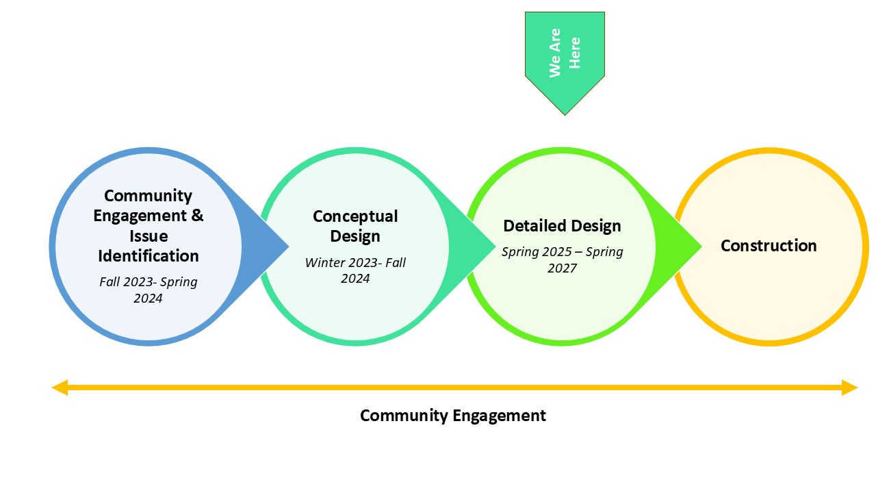
Project Schedule
Project Updates
October 8, 2024: City Council Legislative Meeting
Staff presented a project overview to City Council to seek approval to convert a portion of the King Street Access Road from two-way to one-way westbound, between South Taylor Street and Menokin Drive.
City Council voted 6-1 in favor of the request, permitting the conversion of a portion of the access road.
September 2024: SmartScale Application
City Staff submitted an application to VDOT's SmartScale program for construction funding for the King Street-Bradlee Safety and Mobility Enhancements Project. If awarded, funding would be available in FY 2032. An initial scoring of the application is expected in January 2025 with notification of award in June 2025.
June 25, 2024: City Council Legislative Meeting
Staff presented a request to City Council for a Resolution to Support Grant Applications to the Virginia Department of Transportation for Fy2030-FY2031 SMART SCALE projects.
City Council voted unanimously to provide a resolution to support the requested grant applications. Grant applications are due Summer of 2024 and awarded in Spring 2025.
**Action taken by City Council is to permit staff to apply for grant funding to seek construction funding for the project. This project will still be required to return to City Council to seek permission to implement the preferred alternative, as recommended by Staff and the Traffic & Parking Board.
June 24, 2024: Traffic & Parking Board Public Hearing
Staff presented the preferred design alternative at the June 24th Traffic and Parking Board Public Hearing.
The Board voted unanimously to advance the recommended preferred alternative for consideration by City Council and to approve the installation of a new stop sign and No Turn on Red signs.
May 16, 2024: Virtual Presentation for Preferred Design Concept
Staff presented a project update to share the preferred design alternative, "One-Way Traffic & Bus Lane," along with decision metrics and interim safety improvements for the study area. Materials from the virtual presentation are below:
May 1, 2024: Corridor Plans for Alternative 1 and Alternative 2
In advance of the Community Meeting to be held on Thursday, May 16, Staff is posting the corridor views of Alternative 1: Two-Way Traffic with Transit" and "Alternative 2: One-Way Traffic & Bus Lane" so they may be reviewed in advance of the meeting. These alternatives will be discussed during the meeting.
April 29, 2024: Presentation to the Traffic and Parking Board
Staff presented an overview of the King Street-Bradlee Safety and Mobility Enhancements Project to the Traffic and Parking Board, including two alternatives with corridor-wide plan views, interim safety improvements and next steps.
February 15, 2024: Open House
Staff hosted an Open House on February 15, 2024 at the Fairlington Presbyterian Church. Information on existing conditions, proposed alternatives, corridor-wide safety treatments and next steps were shared. Materials shared at the Open House are available below.
- Presentation from the Open House (English)
- Recording of the presentation
- Presentation from the Open House(Spanish)
- Boards from the Open House(English & Spanish)
December 2023: Project Update
- A brief presentation with project updates
Frequently Asked Questions
As a Vision Zero Community, the City of Alexandria seeks to eliminate fatal and severe injuries on our streets and uses a safe system approach of designing and managing our transportation system to reduce opportunities for crashes and reduce potential crash severity. In the 2016 Transportation Master Plan, and the subsequent 2021 Alexandria Mobility Plan, this area was identified as a priority location to install bicycle facilities and improved sidewalks to connect critical gaps in the City’s existing network. In 2022 the city undertook a Vision Zero Analysis of crash history between 2016-2022 and identified a limited number of corridors where most crashes occur; the study area is located on one of those corridors. This corridor is also one of the City’s high-frequency routes for the DASH bus, with buses every 3-4 minutes during peak demand; improving system reliability and timing in the study area will improve operations for the entire DASH network.
This project seeks to address several goals, including:
- Improve the mobility, safety and access for all roadway users of all ages, abilities and modes of travel; making it safer and easier for everyone to safely navigate through the city.
- Install safer pedestrian access and bicycle facilities which connect to the surrounding network; creating more comprehensive and safer routes for pedestrians and cyclists to navigate the city.
- Improve existing stormwater treatment in the corridor to reduce instances of standing water; improving environmental conditions and the visual appearance of the study area.
- Maintain or enhance existing transit facilities; making it safer and faster for buses to navigate the study area and provide more reliable service for all riders.
This project will provide benefits to a wide range of people. People walking will have improved sidewalks with more space and shorter roadway crossings, making it easier to cross King Street. People driving will have fewer conflicts with buses and people walking or biking, making it easier to navigate the roadways. People taking the bus will have more connected sidewalks, more reliable bus service, new crosswalks to reach bus stops and upgraded bus shelters and waiting areas. And people riding bikes, e-bikes or scooters will have a separate space from pedestrians or vehicles, reducing the potential for conflicts.
This process began in Fall 2023 and staff has utilized a variety of outreach methods to engage with the community on the project design. Please see the community engagement summary, found in the presentation posted under the May 16th “Project Updates” to understand the process and outreach.
In each alternative, eastbound buses would use the access road while westbound buses would share a travel lane with vehicles on King Street. However Alternative 2 proposes a dedicated bus lane in the access road from North Taylor Street to Menokin Drive, enabling buses to move more efficiently through the study area and provide more reliable service. With this option, people driving do not have to wait behind buses loading and unloading that come as frequently as every 3-4 minutes. A shared bus shelter for eastbound and westbound buses is proposed in the median between King Street and the access road to allow for improved bus stops and service along the study area.
A wider sidewalk and separated space for bikes and scooters offers several benefits including safety, accessibility, economic and environmental.
- Safety: Providing dedicated spaces for pedestrians, vehicles, bicycles, and scooters reduces the risk of accidents and collisions by minimizing conflicts and ensuring safer movement for all.
- Accessibility: A wider sidewalk accommodates more pedestrians, including those with strollers, wheelchairs, or mobility aids. It enhances accessibility for all individuals, regardless of their mode of transportation or physical abilities.
- Economic: Creating a pedestrian-friendly environment can boost local businesses by attracting more foot traffic. Cyclists and scooter users may also stop and patronize shops or restaurants along their route, contributing to the local economy.
- Environmental: Encouraging cycling and scooter use as alternative modes of transportation reduces reliance on fossil fuel-powered vehicles, leading to lower carbon emissions and mitigating the impacts of climate change. As more people choose to bike or scooter, it reduces the number of vehicles on roadways and can reduce traffic volume for other drivers.
Currently, there is no funding for construction. The City is applying for construction funding through the Virginia Smart Scale Program for FY 2023. Applications are due in Summer 2024 and projects would be recommended for funding in Spring 2025. At a minimum, construction is many years out. However, the project team is looking to advance some interim safety measures identified through this project over the next year or two.
Yes, the project concepts include new treatments for stormwater and additional trees and greening of the streetscape. Once the design phase begins, the team will have more information about the stormwater plans.
No, the curb cuts are private property, and the City is not proposing any changes to the location or number of these entry points to the access road.
Changes to drivers are minimal if they are coming from the existing roadways. People who live directly on the service road might have to change their traffic patterns slightly if they need to access the shopping center by car, but overall travel times for everyone do not vary significantly with the proposed two-block conversion.
Stay Informed
Want to stay informed of project updates? Please click the following link to sign up for email updates regarding the King Street - Bradlee Safety & Mobility Enhancements Project: Sign up for Email Updates