What's New
Since the November 2024 City Council approvals of the Duke Street Transitway concepts, staff has been working to advance the next phase of design. The City has assembled its project team with the award of the Owner Advisor contract in February 2025 and the design consultant contract to AECOM in July 2025. With a top-notch team now on board, the project has hit the ground running and is moving full speed ahead into design.
This Winter and Spring, you may notice survey crews and other field work along Duke Street as the team gathers important information to move the project design forward. The first set of design plans will be submitted in Spring 2026. Concurrently, the construction firm will come on board and begin working side-by-side with the design team. Bringing the builder into the process early helps identify potential challenges, refine costs, and ensure the project stays on schedule.
Design will continue to advance over the next two years, with final design anticipated in Spring 2027. Permits are expected to be completed by mid-2027, and construction is planned to begin shortly after that.
Throughout this process, the City will provide regular project updates and engage the community at key points when design decisions are needed. We will also begin early outreach to local businesses to work through construction impacts and ensure coordination. In addition, the project team is working closely with the Duke Street Small Area Plan process to align the Transitway with the broader vision for the corridor. Together, these efforts will help deliver a more reliable, efficient, and accessible Duke Street.
Keep up to date on this project and others in the area by signing up for the Duke Streets Projects eNews.
Project Progress
- On November 12, the City Council considered updated concept plans for the Duke Street Transitway. The Council approved staff's recommendation but modified the service road between West Taylor Run Parkway and Cambridge Road to support a partial one-way conversion, leaving the street two-way east of Longview Drive. View the November 12 Council Video.
- The Traffic and Parking Board held public hearings in May and June to make recommendations on the outstanding design elements for the project.
- At the May public hearing, the Traffic and Parking Board recommended that the service road between Moncure Drive and West Taylor Run Parkway be converted to one-way westbound with dedicated space for people biking and walking. View Option 1 and Option 2 concept plans.
- At the June public hearing, the Traffic and Parking Board recommended that the service road between West Taylor Run Parkway and Cambridge Road be converted to one-way westbound with dedicated space for people biking and walking. View Option 1, Option 2, and Option 3 Concept plans. Additionally, the board recommended approval to create a right only lane for eastbound for eastbound Duke Street at South Quaker Lane. View Concept.
- The Project Team provided an oral update to City Council in May 2024 to get their feedback on remaining design elements of the project.
- The City hosted a community meeting on December 14: presentation
- Read the update to City Council on the Duke Street Transitway project.
- View the presentation and video from the November community discussions on Cambridge/Roth intersection and service roads.
Key Project Resources
- Advisory Group Recommendation
- Review updated FAQs about the project prepared in advance of the Council meeting.
- Corridor Roll Plots (Updated April 2026)
- Proposed Station Information (Updated June 2023)
- Complete June 27th Council Materials
To learn more about all the ways the City is working to make Duke Street work better, please visit alexandriava.gov/transportation-planning/duke-street-projects.
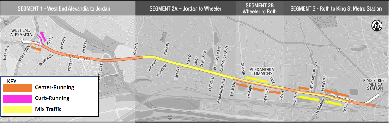
Duke Street Transitway Overview
The Duke Street corridor was first identified in the 2008 Transportation Master Plan and then reaffirmed in the 2012 Transit Corridors Feasibility Study and the 2021 Alexandria Mobility Plan as one of the City’s three high capacity transit corridors, along with the Metroway on Route 1 and the West End Transitway. The Northern Virginia Transportation Authority has awarded the City a total of $87 million dollars for the planning, design, and construction of a transitway along the Duke Street Corridor from Landmark Mall to King Street Metro Station. From the summer of 2021 to the summer of 2023, the City worked with the community and the Duke Street in Motion Advisory Group to identify a vision for the corridor and develop some concept plans for implementation with NVTA funds.
*Additional planning work will occur in summer/fall 2023 to consider the inclusion of separated bicycle and pedestrian facilities in Segment 3.
The concept plan was endorsed by Council on June 27th, 2023. Staff are working to finalize the planning phase through the end of 2023 and aim to begin the design phase in early 2023. The schedule is still being finalized, but construction could begin as early as 2026.
Advisory Group Meetings
Advisory Group Mission and Members (Membership updated November 2022)
- DRAFT AGENDA
- PRESENTATION
- RECORDING
- ADOPTED MEETING MINUTES
- ADVISORY GROUP MEETING #4 DRAFT MEETING MINUTES
- ADVANCE MATERIALS PACKET
- AGENDA
- BUS STATION ITEMS STATUS
- CONCEPT FACT SHEETS
- COMPARISON MATRIX
- DATA PLAN
- VIRTUAL MEETING POLICY
The next Advisory Group meeting will take place on August 18, 2022 at the DASH Facility at 3000 Business Center Drive from 6:30 to 8:30 PM. Members of the public are welcome to attend either virtually or in person. To register for virtual access, use this link.
DRAFT AGENDA (REVISED 8-16-22)
ADVISORY GROUP MEETING #3 MINUTES (adopted)
- AGENDA
- DRAFT DUKE STREET TRANSITWAY PROJECT VISION AND GUIDING PRINCIPLES
- DUKE STREET TRANSITWAY ADVISORY GROUP MISSION AND CHARGE
- DUKE STREET PLANNING SEGMENTS
- ADVISORY GROUP MEETING #1 PRESENTATION
- ZOOM MEETING RECORDING (Note: Meeting starts at the 29-minute mark. There is a break between the 1:42 and 1:52 minute marks.)
Newsletters
Our quarterly newsletters keep you up to date on project status. Sign up for eNews alerts to receive updates and information about the City's many projects aimed at improving travel along Duke Street; for opportunities to participate in community meetings; and ways to provide feedback. Select "Duke Street Projects" when choosing your subscriptions.
To learn more about all the ways the City is working to make Duke Street work better, please visit alexandriava.gov/transportation-planning/duke-street-projects
Phase 3 - Preferred Concept
Phase 3: Preferred Concept Documents
- Summary of Metrics (April 2023)
- Travel Time Comparison Detail - AM and PM (Updated with AM May 2023)
- Open House Boards (similar to presentation PDFs; includes a map showing changes in walk shed) (April 2023)
- Busway Concept A, Curb Feature Y - Preliminary Roll Plot (April 2023)
- Busway Concept B, Curb Feature Z - Preliminary Roll Plot (April 2023)
- Open House Comment Period
- Cameron Station Precinct Meeting
- Email comments from individuals - Phase I and II
- Email comments from individuals - Phase III
Phase 2 - Concept Development Engagement Materials (Fall 2022)
Thank you to everyone who provided input during our October engagement on bus design concepts for Duke Street! A summary of input is available here.
See below for Fall 2022 engagement meeting materials:
- Recorded overview presentation
- Presentation PDF with transcript (español)
- Busway concept fact sheets and comparison tables:
- Vision and guiding principles
- Meeting Boards (Existing Conditions Bus, Existing Conditions Vehicle Travel, Comparison of Busway Alternatives - Safety, Comparison of Busway Alternatives - Travel Times)
- Segment 1 Presentation
- Segment 2 Presentation
- Segment 3 Presentation
- Other Phase 2: Concept Development Documents
Phase 1: Visioning Community Feedback Results (2021)
The City of Alexandria has compiled the results of more than 1,800 feedback form responses from both online and in-person pop-up events for the Duke Street In Motion project. Watch the video below for a brief overview of some of the findings from the community's input.
Community Input Summary: The City has compiled the results of the feedback forms and provided a summary report of the findings of your input. If you are interested in seeing all the data submitted, the complete results are available in this sortable Excel file.
Phase 1 Outreach
- Webinar Recording
- PowerPoint
- PowerPoint (Spanish)
- Pop Up Events Locations (June 21-28, 2021)
Historical and Background Resources
- Transitway Corridor Feasibility Study (2012)
-
2012 Concept Plan Fact Sheet (Developed in 2022)
- Transitway Work Group Recommendation to Council (2012)
- City Council Presentation and Resolution on Preferred Alternative for Transitway Corridors (2012)
- Memo to Council on History of Corridors B (Duke Street) and C (West End Transitway) (2018)
-
Other Phase 1: Visioning Documents
- Duke Street NVTA Application (2018)
- Duke Street NVTA Application (2020)
- November 24, 2020 City Council Presentation
- February 14, 2023 City Council Project Update
Frequently Asked Questions
These FAQs will be regularly updated. If you have a question that is not on here, you can email jordan.exantus@alexandriava.gov.
City Council has prioritized a transitway along the Duke Street starting in the 2008 Transportation Master Plan. Numerous City Councils have shown continued support over the past 15 years to meet the following priorities:
- Improve access to jobs and opportunities - especially important for minority populations
- Manage traffic congestion
- Reduce air pollution and carbon emissions
- Meet the needs of development
- Increase safety
- Improve quality of life
Right now, taking the bus on Duke Street is slower and less reliable than driving, but the corridor still has the highest ridership in the City. A more efficient, reliable and comfortable bus service – with safe connections – will make it a more attractive option. Otherwise, congestion will continue to get worse.
Cut-through traffic is a major concern in this area, and making Duke Street work better will likely help to keep drivers on major roadways and off neighborhood residential streets. As part of this project and others on Duke Street, signal timing, new Smart Signals, transit signal priority, and other improvements will help make Duke Street flow and could reduce cut-through traffic.
Learn more about related projects:
Bus Rapid Transit (or BRT) systems aim to make bus transit more efficient, reliable, and comfortable. In general, BRT is a flexible system of facilities, equipment, services, and amenities that improve the speed, reliability, and identity of the bus. Specific BRT elements vary but may include:
- Upgraded bus stations with enhanced passenger amenities
- Faster and easier boarding
- Transit signal priority enabling buses to stop less often at red lights. (You can see a video about this technology here.)
- Dedicated bus lanes that can function similar to a railway
- Queue jump lanes to allow buses to bypass traffic when they don’t have their own lane
- More frequent service
Dedicated lanes are not a required element of BRT, but they help make other elements like transit signal priority more effective, getting buses out of traffic and increasing reliability.
The PM peak is the most congested period of the day. End-to-End corridor travel time savings in the eastbound is estimated at 9.5 minutes for buses (from 25 minutes to 15.5 minutes) and 5 minutes for other vehicles (from 19.5 minutes to 14.5 minutes).
The Westbound AM is the only direction seeing a net increase in vehicle travel times (from 11 minutes to 13.5 minutes).
Because the increases in vehicle travel times vary by segment and direction, most roundtrips on the corridor will result in a net savings in vehicle travel time.
| West End to Old Town | Old Town to West End | ||
|---|---|---|---|
| Car | 2 min (Concept A) | Car | 1.5 min (Concept A) |
| Bus | 11 min (Concept A) | Bus | 16 min (Concept A) |
| Jordan/Fox Chase to Old Town | Old Town to Jordan/Fox Chase | ||
|---|---|---|---|
| Car | 2.5 min (Concept A) | Car | -3.5 min (Concept A) |
| Bus | 9 min (Concept A) | Bus | 8 min (Concept A) |
| West End to Old Town | Van Dorn to Jordan | ||
|---|---|---|---|
| Car | 5 min (Concept A) | Car | 4 min (Concept A) |
| Bus | 15.5 min (Concept A) | Bus | 7 min (Concept A) |
| Jordan/Fox Chase to Old Town | Quaker to Jordan | ||
|---|---|---|---|
| Car | 2.5 min (Concept A) | Car | -1 min (Concept A) |
| Bus | 9 min (Concept A) | Bus | 2.5 min (Concept A) |
Travel times on Duke Street may decrease related to transit signal priority and traffic signal modifications to provide more green time for Duke Street.
While side street delay may increase, cut-through traffic may elect to take other routes, so it is difficult to say the net impact to side streets.
Duke Street is one of the city’s high crash corridors. There were 632 total reported crashes between 2016 and 2020, including:
- 74 left turn angle crashes
- 27 ped involved crashes
- 3 fatalities
- 16 incapacitating injuries
- 168 non-incapacitating injuries
- 22 potential injuries
Busway Concept A would result in the following safety benefits:
- Reduce left turn angle crashes by 70%, which would lead to a 15% reduction in total crashes.
- Reduce ped crashes by 50% at the 29 intersections on the corridor by adding ped refuges where they do not exist today.
- Other intersection safety treatments will be incorporated such as leading pedestrian intervals and no turn on reds.
- Transit riders: Nicer bus stations that are safer and easier to access, and the bus will be faster and more reliable. Some riders may have to walk a little farther to their stop.
- Drivers: Safer because of fewer left turn crashes and from separating buses from traffic. Travel times for most segments of the corridor will likely be shorter. Some left turns will need to make u-turns at a signal, but the turn will be protected.
- Walkers: Wider sidewalks, separate paths from bikes where there is space. Safer intersections, and overall a more pleasant experience.
- Cyclists/Scooter Riders: Separated (where feasible), connected and wider paths for a safer and more pleasant experience.
- School buses: The project team is working with ACPS to identify stops and potential alternative stop locations if the new design impacts existing stop locations.
- Emergency vehicles: Response times will improve by using bus only lanes to get around traffic.
- Businesses: Access to businesses will remain, but it might look different. More people walking, biking and taking transit on a nicer looking corridor is good for business. Construction will likely be a short-term burden.
- Service roads: Access to driveways and parking remains. Some service roads might look different or be converted to one-way for safety and to reduce congestion.
- People with disabilities: Upgraded intersections for safer crossings with new technology. Slightly longer distances between stations might mean farther walks for some people, but others might be closer to new stations.
Any right-of-way needed for this phase would be acquired via voluntary agreements and not through use of eminent domain. The City does not want to use eminent domain and does not envision utilizing that tool in future phases. During this phase, the Advisory Group recommended priorities in cases of trade-offs. Some options could include shifting station location, decreasing widths for shared use paths, or reducing buffers or green space.
Based on community feedback, the residential service roads will remain in place for the entire corridor. Some mostly commercial service roads in Segment 1 would be removed to separate buses, bicycles, pedestrians and general traffic. Access to all businesses would remain but would look different than today.
To achieve a Duke Street that is better for all users, the service road from Cambridge Road to Telegraph Road will be modified in the future. On November 12, 2024, City Council approved staff’s recommendation to keep two-way travel on the service. However, Council modified the service road to include a partial one-way conversion from Longview Drive to Cambridge Road, which includes one-way westbound traffic to separate bicycle and scooter traffic from pedestrians and drivers. East of Longview Drive, the service road will remain two-ways. Overall travel times will likely stay the same since the Duke Street corridor and neighboring intersections will function more efficiently. Final details about the service road conversion will be determined in the design phase.
The slip lane, or right turn into the service road prior to the intersection, is part of the Duke and West Taylor Run project, which is separate but related to the Duke Street in Motion project. The transitway has no impact on the slip lane’s location, though these projects are being closely coordinated. The slip lane will help make the intersection at West Taylor Run safer and more efficient. Based on City Council’s adopted service road concept, the right-turn into the service road prior to the signalized intersection will be located between Moncure Drive and East Taylor Run Parkway.
There are some changes to left turn access in isolated locations. Because vehicles will not be able to cross the busway at non-signalized intersections, vehicles wishing to access a destination on the other side of the street between intersections will need to make a U-turn to access those locations. These changes have safety benefits for drivers who no longer have to wait for a gap in traffic to turn across vehicle lanes, but it may result is slightly longer travel times.
During outreach for this project and others, the project team has heard a lot of concerns about issues with traffic, safety and access at the Cambridge Road intersection. To address these concerns, the proposed design reduces conflict points at the intersection for both pedestrians and drivers and creates more efficient traffic patterns aimed at reducing congested and confusing conditions with stop signs and signals. The new design separates turn movements to provide conflict free pedestrian crossings at the intersection and provides new signals to better manage traffic flow. The traffic model showed that the intersection operates around the same level of service, but you also get a much safer intersection.
At Yale Drive, the left turn into Yale Drive from eastbound Duke Street would be removed since there is a planned BRT station to be built in the median space. Wherever there is a dedicated use of the center space of the roadway, like a center lane or median, drivers must go to the next intersection and make a U-turn, like they do on Route 1. Rather than waiting for a gap in traffic to make the turn, they would have a protected turn at a signalized intersection, which is a major safety benefit for drivers and pedestrians crossing Yale Drive and other streets. Specifically, for turns onto Yale Drive, drivers would have to go an additional 80 feet to turn at the signal. Left turns are already prohibited from turning out of Yale Drive onto Duke Street. Traffic counts show that 40 and 27 vehicles turn left onto Yale Drive in the AM and PM peaks, respectively. The community has expressed concern that these cars will now use Cambridge Road instead of Yale Drive. While some people making this turn onto Yale Drive now might shift to Cambridge Road, it is unlikely that the impact would be noticeable.
Currently DASH and Metrobus run buses on Duke Street, and these will continue. With regards to stops, Metrobus stops are currently about a half mile apart and DASH bus stops are about every block. Once this project is completed, all buses will stop at all proposed stations on the corridor, meaning that a passenger going towards the King Street Metro can simply take the first bus that arrives, making the wait times shorter and more convenient. All stops will be on average .4 miles apart or a maximum of a 4 minute walk (for an average person) once on Duke Street.
A guiding principle of Duke Street in Motion is sustainability, and an overall goal of this project is to increase greenspace and tree canopy. Some trees will need to be removed with construction, and this will be mitigated with new tree plantings or other features. Trees would need to be removed because of median changes and shared use path widening. During the design phase, an arborist will examine existing trees to help inform preservation and mitigation strategies.
With any project of this size, construction will be disruptive, but the detailed schedule for construction and specific impacts will not be known until the project is more fully designed. The City will keep the community informed and will seek to minimize impacts as much as possible. During the design phase, the project team will create a transportation maintenance plan and schedule. Direct access may be changed but temporary routes or detours will be made available when necessary.
Yes. This project will likely improve emergency vehicle response time by using dedicated lanes and signal priority to bypass traffic. The Project Team has been working with representatives from Fire and Police and will continue to do so as design advances. The Alexandria Fire Department has indicated a preference for Concept A.
Traffic models are tools that can help us understand and predict traffic behavior such as changes to the transportation system (new roads, new transit lines, or changes to traffic signals). Traffic models can also be used to plan for future transportation needs.
This study’s traffic model used Vissim, a traffic simulation software, with vehicle data from May 2022. Looking at both morning and afternoon peak times, the team developed a 2030 Business as Usual scenario using projected traffic growth in the corridor and planned transportation investments. Twelve model runs were conducted for Corridor Concept A, B, and Business as Usual to understand potential travel times for drivers and bus riders as well as bus reliability. These travel runs represent a typical day along the corridor.
The following assumptions were included in the traffic model:
- The bus lanes are only used by those authorized (buses, emergency vehicles)
- Projected growth in demand for the corridor will be realized.
- Planned transportation investments will be completed as scheduled.
- Traffic behavior will remain constant.
It is important to view traffic models as a tool, not as a perfect representation of reality. Traffic models are based on a number of assumptions based on historical data and planned growth, and these assumptions can introduce some uncertainty into the results. The accuracy of the model's predictions will depend on how well these assumptions hold true in the future.
Once the final concept plan is approved, staff will move forward with the procurement of a design consultant. Community engagement will continue. The schedule will be developed as part of this process and will depend on the procurement method, but the high-level project schedule is as follows:
Spring 2021 - Fall 2024: Community Visioning and Concept Development
Summer 2025 & Summer 2027: Detailed Design & Environmental work
2027 & 2028: Construction
Per the Northern Virginia Transportation Authority (NVTA), grantees are required to demonstrate substantial progress within 18 months of a grant agreement. The initial agreement for the first $12 million began in April 2019. Funds for construction became available in FY24. The City applied for funding based on the analysis of the 2012 plan, which included TSP and dedicated bus lanes. A major change in the anticipated benefits would require review by NVTA and a potential rescoring of the project.
The model is estimating about 3.5 minutes saved from stop consolidation alone. Bus travel time savings during peak periods range from 4 minutes to as much as 9.5 minutes. The estimated savings from stop consolidation is a conservative estimate because the model used 2018 boarding/alighting data, before fares were free, which has since sped up boarding. Stop consolidation alone does not reduce congestion on the street or help keep Duke Street moving, but it does, along with other design features, play a part in the travel time savings and increased reliability the model shows for buses. Ridership gains from BRT are related to both the travel time savings and the higher quality of service that BRT provides – not from stop consolidation alone. Dedicated bus lanes also have a benefit for cars by eliminating the need to weave around buses.
Existing Ridership
Overall corridor ridership has grown steadily since the pandemic. DASH is working to validate its Automated Passenger Count (APC) ridership data for use by the FTA but has provided conservative estimates of ridership using a combination of existing methods and APC data.
| Route | 2018 | Fall 2022 | Spring 2023 | Fall 2024 | % pre-COVID |
|---|---|---|---|---|---|
| 30 | 1,948 | 1,503 | 1,819 | 3,429 | ↑176% |
| 28A | NA | 637 | 693 | 1,915 | NA |
| 29K/29N | 666 | 619 | 590 | 571 | ↑86% |
| Total | 2,614 | 2,759 | 3,102 | 5,915 | ↑126% |
Ridership Projections
The model projected about a doubling of ridership with the introduction of the new infrastructure. The Project Team used an FTA model to project ridership for 2030. The main inputs in the model are existing transit service provided, bus and vehicle travel times, bus ridership and land use data as well as projected transit service provided, land use data and bus and vehicle travel times. BRT is assumed to be a more desirable option than a local bus.
The Pulse, a BRT example in Richmond, experienced ridership twice as high as service goals within the first year of service.
The City currently has $87 million in non-City grant funding to plan, design and construct this project. A cost estimate was developed at this 10% level of design based on current FTA guidance for contingency and inflation. For most components, a contingency percentage of 35-40% was applied. Annual escalation of 4% was applied based on FTA guidance on similar projects for FY24 and beyond. Escalation was based on construction starting in 2027, which is a conservative estimate of schedule and resulted in a total escalation of 17% being applied to construction items. Based on the recommendation as laid out in the preferred concept roll plot, the current cost estimate is as follows:
- Total Project Cost (including Escalation and Contingency): $97 million
- Escalation Amount: $10 million
- Contingency Amount: $27 million
- Estimated Cost in today's dollars without Contingency: $60 million
- Design Cost (including Escalation and Contingency): $6.5 million
- ROW/Utilities (including Escalation and Contingency): $14 million
- Construction (Including Escalation and Contingency): $77 million
As the selected concept advances through the design phase, the accuracy of the estimate will increase project elements can be scaled up or down accordingly. The Advisory Group specifically prioritized converting Segment 2B from Wheeler to Roth from a single direction center running bus lane to mixed traffic as a cost saving measure. This change alone would save about $8 million (including contingency and escalation) and another $2-3 million could be saved by deferring changes to curb features until redevelopment occurs.
If needed and directed by Council, staff can seek additional grant opportunities funding for future project phases. There are many sources of funding for BRT, particularly in this region, including:
- The Northern Virginia Transportation Authority (NVTA) is actively seeking to increase funding for BRT projects
- State funding (i.e. SMART SCALE)
- Federal funding could be available sooner since there are more grants available as part of the Bipartisan Infrastructure Law.
Contact
If you have any questions, please contact Jordan Exantus, Transit Program Manager at jordan.exantus@alexandriava.gov.