Schematic Landscape Design
For over a decade the City of Alexandria has worked towards addressing the perennial issue of flooding along Alexandria's waterfront from these sources. On February 12, 2012, City Council adopted a Waterfront Small Area Plan (Waterfront Plan) that would establish a vision for the development of Alexandria’s waterfront residential, commercial, and infrastructure assets. City staff started working with consultant teams from OLIN and URS Corporation the following year to develop schematic design documents depicting the vision of the Waterfront Small Area Plan.
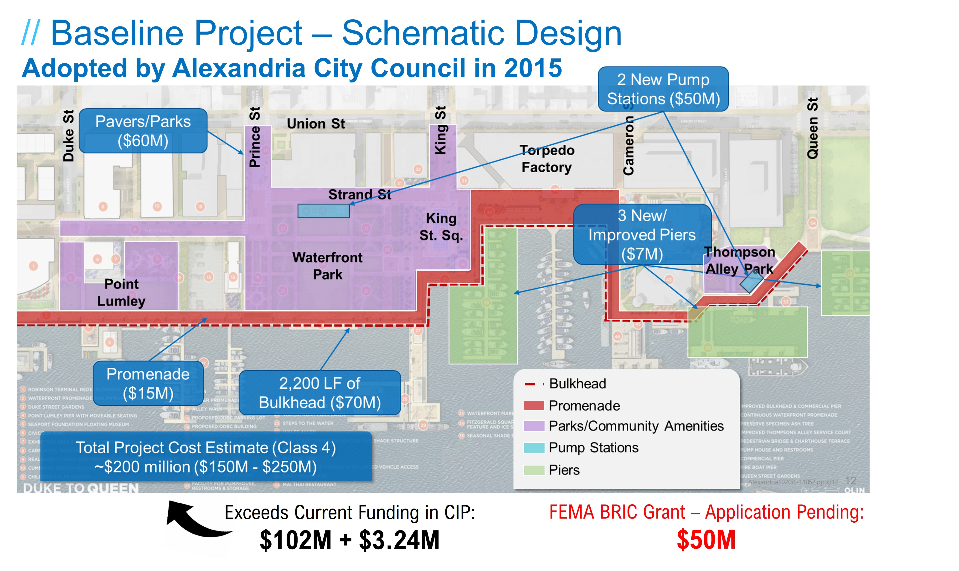
Council approved the draft 15% Schematic Landscape Design on June 14, 2014.
Schematic Landscape Design Development Process
Phasing and Funding Plan
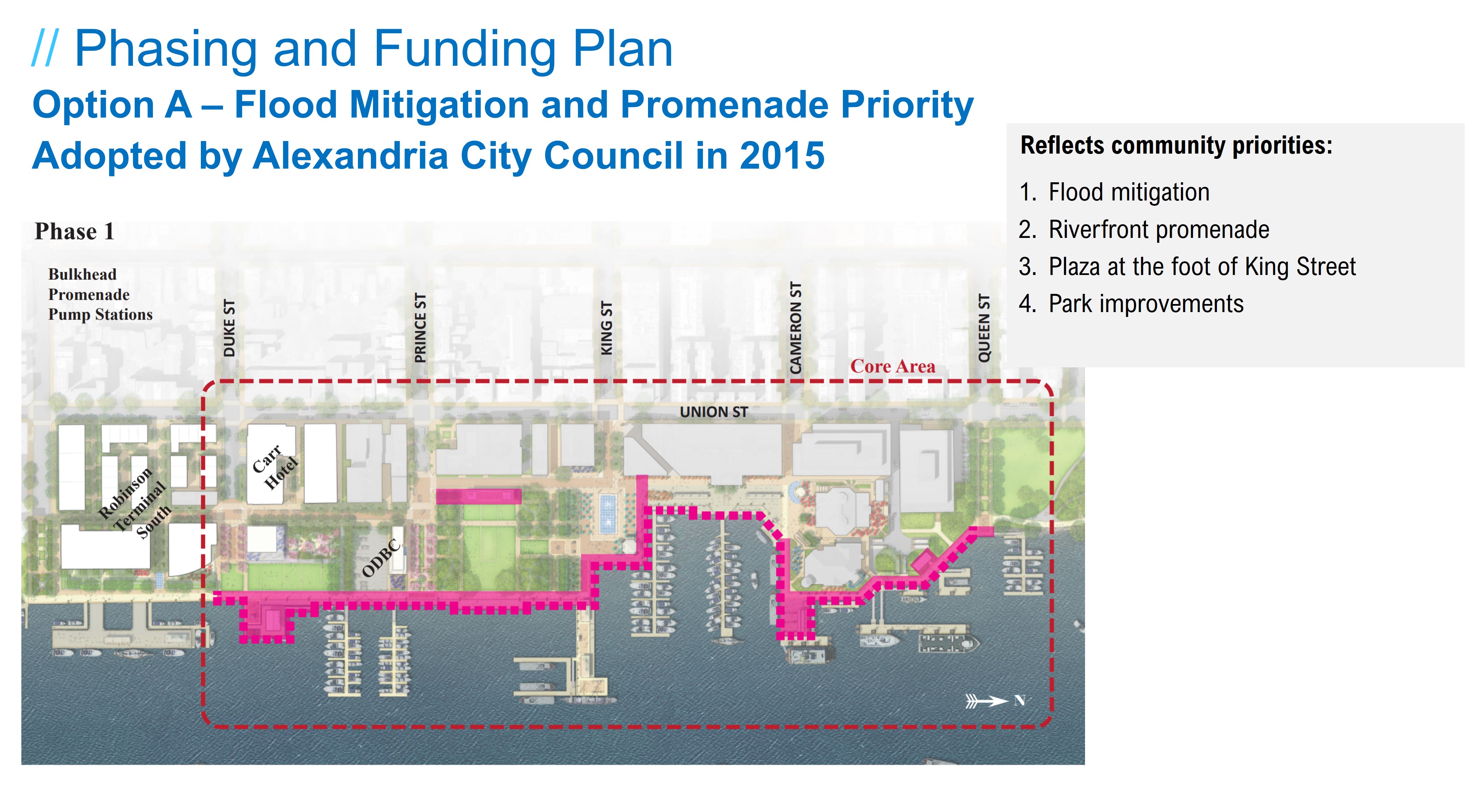
On January 27, 2015, Alexandria City Council received and adopted "Option A – Flood Mitigation & Promenade," a phasing plan for implementation of the Waterfront public improvements, which was generally consistent with the following initial order of implementation:
a. completion of core area utility, roadway and other infrastructure construction required to support subsequent improvements;
b. competition of flood mitigation elements;
c. completion of Waterfront Park improvements; and,
d. completion of remaining park improvements inside the core area.
Phasing and Funding Plan Development Process
Design Analysis: Constraints and Challenges
After issuing this guidance, the City developed many of the preliminary engineering reports necessary to develop the Schematic Landscape final design. These reports indicate that the Schematic Landscape design alternative adopted by City Council would be appropriate for addressing flooding and providing public amenities in accordance with the Waterfront Plan; however, the City concurrently learned of four major additional constraints and challenges that ultimately necessitated a re-evaluation of the City’s priorities and approach to flood mitigation:
The City adopted the Environmental Action Plan 2040 and enacted the Green Building Policy in 2019, which requires public development to “treat 100% of the required stormwater treatment through green infrastructure.” These policies and plans build and strive towards implementation of the vision laid out in the 2008 Eco-City Charter.
New local and state regulatory requirements (primarily pertaining to stormwater quality) established since 2015 that need to be addressed by the project were not included in the Baseline project or early cost estimates. The City’s 2019 Green Building Policy indicates these water quality requirements for nutrient reductions shall be addressed on-site via green infrastructure. Accordingly, the City must use practices approved by the Virginia Department of Environmental Quality (DEQ) to comply.
Storms of increasing intensity and frequency have been hitting our region, causing localized flooding and subsequent damages to property and businesses. This is a trend also observed around the country and planet. Accordingly, the City has re-evaluated the recommended size and intensity of the “design storm” used as the basis for stormwater and flood mitigation infrastructure performance requirement calculations. Use of this updated model will facilitate the development of more informed alternatives, without dramatically increasing costs to the project.
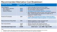
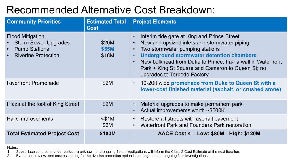
Anticipated costs of implementing flood mitigation infrastructure projects, as well as regulatory and policy compliance costs have increased dramatically since the Baseline project budget was developed. Projected costs for the Schematic Landscape design alternative in 2021 dollars are calculated to be approximately $200 million. Due to an increase in the number of competing CIP projects, and the continued escalation of their related costs, it is currently not anticipated that the CIP budget can provide sufficient funding within the 10-year CIP to provide this level of funding. In response, the City has aggressively pursued more cost-effective alternatives that achieve the goals of the Waterfront Plan and alternative funding sources that help achieve the flood mitigation and public amenity goals without additional burden on the City’s CIP and debt service.
A New Approach
In light of the newly identified constraints and the potential for additional future challenges, the City pursued an approach to the final design development process that would generate the best overall plan for addressing the goals and objectives of the Waterfront Plan’s prioritized “Core Area” (Waterfront section running from Duke Street to Queen Street), while also reducing overall costs and scaling the project to the target budget threshold of $100M.
Core Area Goals and Objectives
- Mitigate stormwater flooding
- Develop new civil infrastructure (inlets, pipes, storage, pumps, etc.)
- Scale project to a conservative baseline storm size
- Reasonably account for climate change projections through 2100
- Eliminate capacity issues
- Replace aging or failed bulkhead and shoreline infrastructure (where feasible and affordable)
- Develop new civil infrastructure (inlets, pipes, storage, pumps, etc.)
- Eliminate backflow of Potomac River into streets
- Address most frequent overtopping of bulkhead/shoreline – but not all
- Policy and regulatory compliance
- Deliver on goals of Waterfront Small Area Plan
Alternative Development Process
To do this, the City utilized a process that integrated resiliency, sustainability, regulatory compliance, and value engineering into the alternative development process. From March 2021 to February 2022, the City and project team completed the following steps to identify a recommended Cost-Based Alternative for the Waterfront Implementation Project:
- Researched, compiled, and analyzed potential approaches to value engineering and project phasing.
- Developed a series of Alternatives to the Baseline Project with and without budget constraints that:
-
Support the community’s flood mitigation priorities, as affirmed by City Council,
-
Address changes resulting from the use of the updated “design storm” model,
-
Mitigate the sources of most frequently occurring floods, and
-
Achieve water quality compliance requirements by incorporating new resiliency and stormwater management best practices.
-
-
Shared the Alternatives with City stakeholders and community members, including the Waterfront Commission - Flood Mitigation Sub-committee, and collected feedback on potential flood mitigation options, risk, and budget tolerance.
-
Refined all designs and identified a Recommended Cost-Based Alternative, given available funding, performance requirements, phasing opportunities, community prioritization and feedback.
Project Alternatives
Recommended Cost-Based Alternative
The Recommended Cost-based Alternative was based on prior cost-based alternatives; incorporated feedback from the Waterfront Commission – Flood Mitigation Committee, Alexandria Archeology Commission, Park and Recreation Commission, and community members; took into consideration the programmatic and accessibility goals of the Waterfront Plan; and, followed a budget-based approach.
The Recommended Cost-based Alternative features:
- Improvements to the stormwater infrastructure, including:
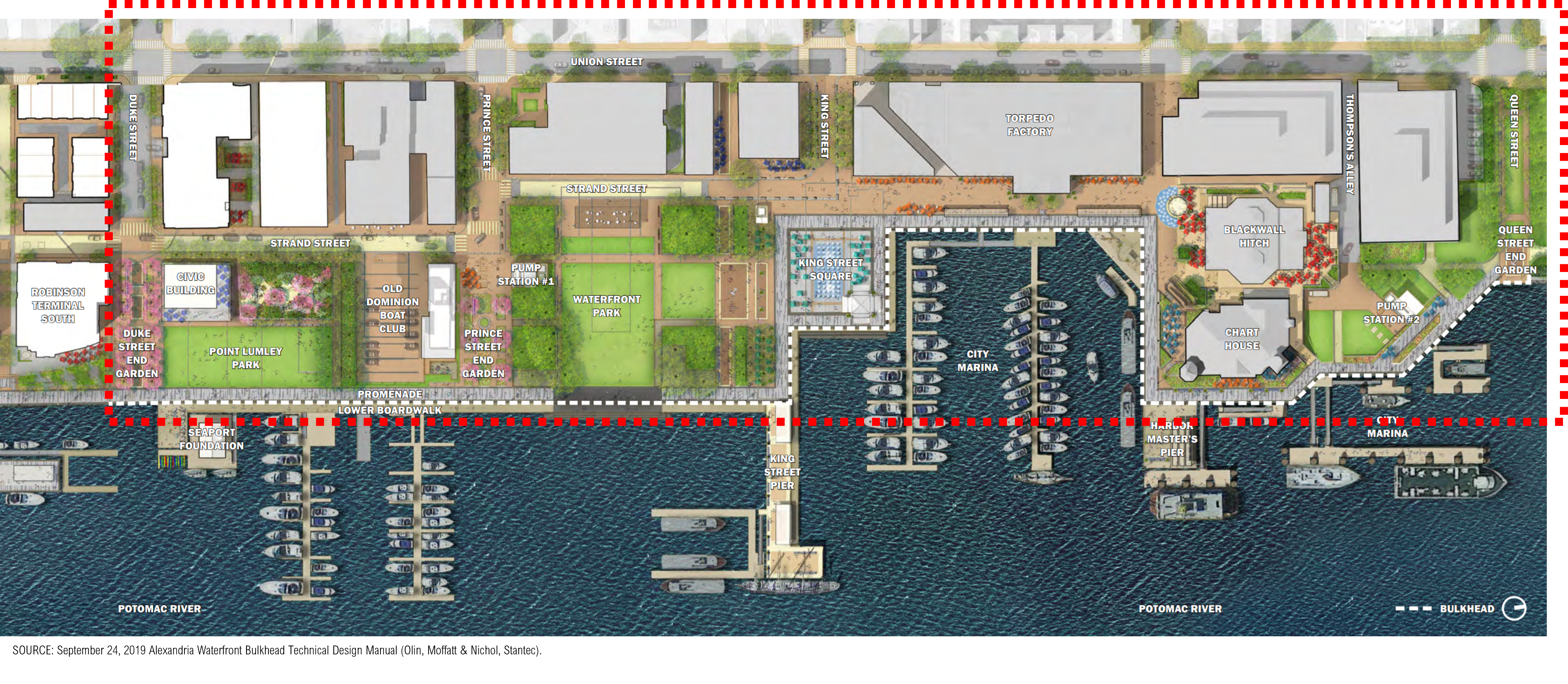
- New/upsized inlets and stormwater conveyance from Duke Street to Queen Street
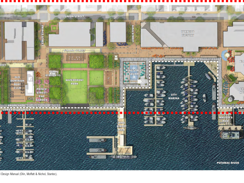
- Installation of two stormwater pumping stations in Waterfront Park and Thompsons Alley (or the foot of Queen Street)
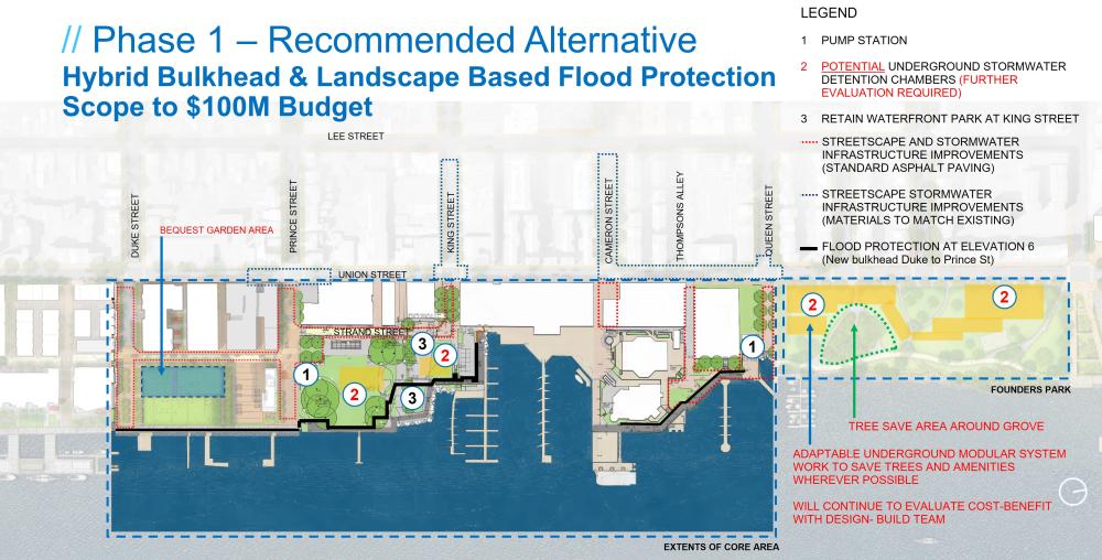
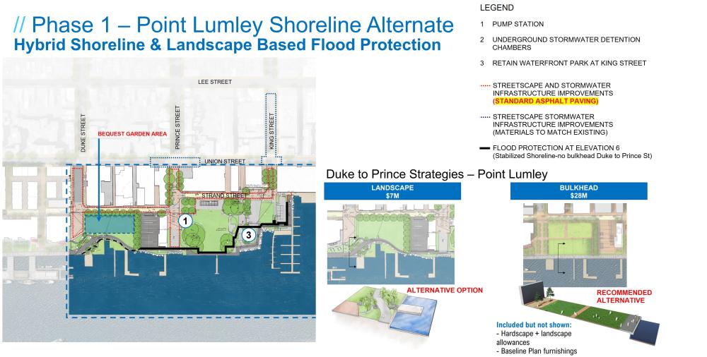
- Improvement of riverine flood protection up to elevation +6.0 feet (in NAVD88), including:
- A new bulkhead from Duke Street to Prince Street
- Landscape-based protection along the remaining vulnerable segments of the waterfront from Prince Street to King Street and from Cameron Street to Queen Street
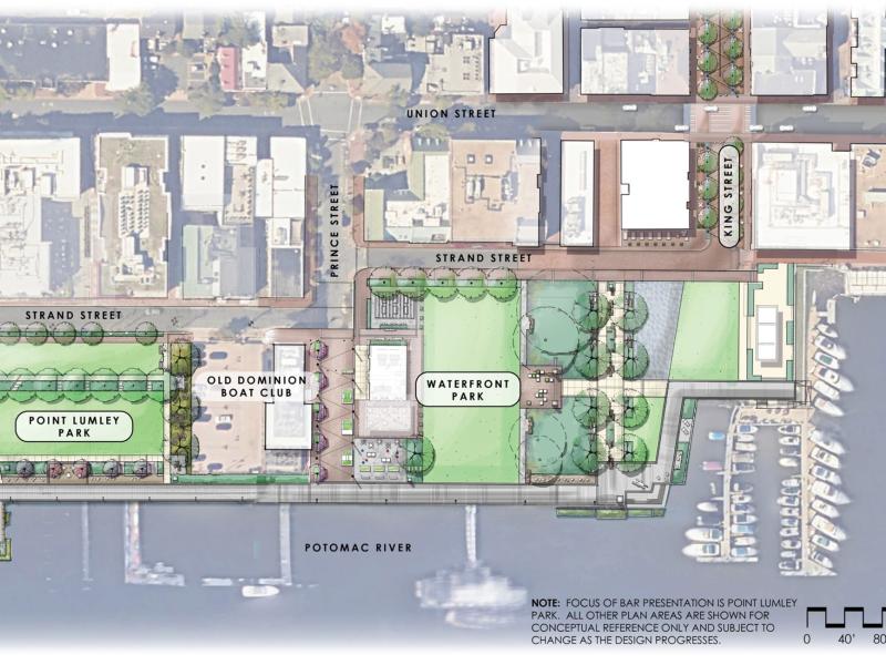
- Restoration of all disturbed areas including asphalt paving to streets and landscape restoration at Waterfront Park, Point Lumley, and Founders Park, if impacted
- No improvements or a new bulkhead in the City Marina adjacent to the Torpedo Factory and Chart House, from King Street to Cameron Street
- Less costly materials used in streets and promenade as compared to the Common Elements
- Restoration of parks to current conditions with few improvements, including Waterfront Park.