You're logged in with MyAlex  |  Logout

City of Alexandria, VA

Search results cleared

Include archived pages
Most of the content here is written in English. Translate your search to find more content? Translating "" to English... Searching for English phrase ""
  • Live
  • Play
  • Services
  • Business
  • Government
  • Projects & Plans
  • Calendar
  • I want to…

Building a Bustling Port

Visit this exhibit in the Alexandria Archaeology Museum
Page updated on December 4, 2024 at 2:00 PM

Alexandria Archaeology

  • Historic Alexandria (Home)
    • The Museums
      • Museum Collections
      • Rentals and Private Events
    • Other Historic Sites
    • Alexandria Community Remembrance Project
    • Alexandria's History
    • Educational Resources
    • Historic Preservation
    • Museum Store
    • Self-Guided Tours
    • Stay Connected
    • Support Historic Alexandria
  • About Historic Alexandria
  • Alexandria Archaeology (Home)
  • Alexandria Archaeological Commission
  • Archaeological Process
    • Alexandria Archaeology Bibliography
    • Documentary Research and Historical Archaeology
  • Archaeology and Alexandria's First People
  • Archaeology and Preservation
    • Archaeological Protection Code
    • Archaeological Standards
    • GIS Tools for the Archaeologist
    • Metal Detecting Code
    • Resource Management Firms
  • Archaeology on the Waterfront
  • Make a Gift
  • News Releases
  • Programs & Events
    • Alexandria Archaeology Summer Camp
    • Educational Resources
  • Projects and Publications
  • Visit the Museum

Share

Bluesky Share on Facebook Share on X Share via Email
Translate icon
Translate icon
XWARNING: You have chosen to translate this page using an automated translation system. This translation has not been reviewed by the City of Alexandria and may contain errors.

18th Century - Building a Bustling Port

You are standing on manmade land that helped create a successful port.

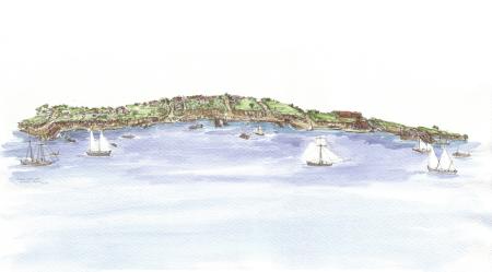
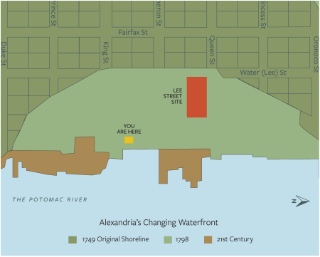
For thousands of years before the arrival of Europeans, Native Americans lived and traveled through the lands that would become Alexandria. The town was founded in 1749 on a bluff above a crescent-shaped bay. The original shoreline was along Lee Street, more than a block inland from where you are now standing. By 1784, the area between Queen and Cameron Streets was filled, making Union Street the new riverfront street.

"Alexandria is beautifully situated near the Falls of the Potomac, one of the finest Rivers in North America, it affords good Navigation for the largest ships in Europe up to the Town, where there is an excellent harbor. '' - The Pennsylvania Gazette March 10, 1763

Watercolor of Alexandria in the 18th century showing tall ships on the Potomac and a small port town in the distance.
Illustration by Elizabeth Luallen

The Changing Waterfront

The natural harbor was too shallow for merchant ships to reach the shore. Free and enslaved people cut down the tall bluffs and used the soil as fill to create new land for wharves and warehouses teeming with seaport activity. One of these wharves was located at the Lee Street Site.

Archaeologist illustration of upright wooden piles and surrounding wooden structures with soil colors marked
Archaeologists uncovered evidence of wooden structures built to hold new land in place. This illustration shows the wooden piles that were driven into the ground to form the bulkhead.
Map made by George Washington in 1748 before Alexandria was founded showing two points of land extending into the Potomac River with a shallow bay in between.
Alexandria as surveyed in 1748 before the town was founded, showing the shallow "Shoals or Flats.” Library of Congress.

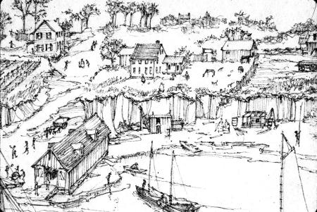
Wharves and Warehouses

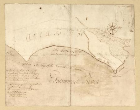
Many wharves dotted the shoreline in the late 18th and early 19th century. By the time this map was created in 1804, the Lee Street Site wharf had become a part of the land. 

Wharves and warehouses provided docks for ships coming in and out of the port and formed the foundation for building out into the river. Merchant ships docked along the Alexandria waterfront to unload and load merchandise. 

Alexandria's main exports were raw goods like tobacco and wheat. The city imported sugar and rum from the Caribbean and manufactured goods from Europe. The exploitation of enslaved people formed the foundation of this trans-Atlantic network.
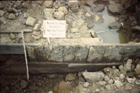
1804 map of Alexandria wharves with an inset showing the location of the Lee Street Site.
The location of the Lee Street Site's wharf is marked in teal on this map. 1804 Deed Book E-2, page 269.

Making Land on Lee

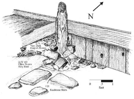
Archaeologists uncovered over 100 feet of a wooden wharf that extended east into the Potomac. 

Two long lines of wooden posts were driven into the ground to hold new soil in place and extend the land into the river. Wharves were an important part of controlling the shoreline and making it useable.
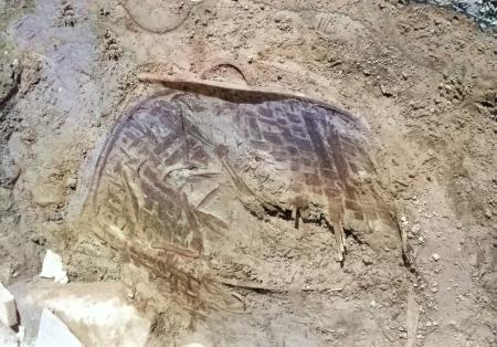
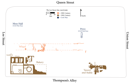
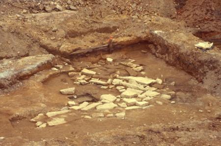
Wharf

Archaeologists documented the remnants of an 18th century wharf on the Lee Street Site. The dashed lines show the likely edges of the wharf.


Simplified map of the Lee Street Site, showing the 18th century wharf
The 18th Century wharf is shown in the center on this map of the Lee Street Site (44AX180). 
Flat paving stones are exposed in an excavation unit
Paving stones were found on top of the manmade land.
Archaeological excavation shows vertical wooden planks holding land in place.
Wooden structures were built to hold the new land in place.
Map showing the 1749, 1798, and modern shoreline of Alexandria with the Lee Street Site highlighted
The Lee Street Site shown in red is on land created after George Washington’s 1749 map of Alexandria shown in dark green.

Rivers as Roads

The river connected Alexandria to the world. It was the way that people, information, and goods traveled. Newspapers, ship manifests, and customs records show the cargo that merchant ships carried and the places they traveled.

Illustration of 18th-century Point Lumley showing workers loading and unloading cargo from ships on the Potomac River. A warehouse is on the shore, with buildings and farmland in the distance.
The waterfront was a busy place. Cargo was stored in warehouses before being sold in Alexandria or exported. Illustration of the 1755 Carlyle Warehouse at Point Lumley by Elizabeth Luallen.
A smashed woven wooden basket is exposed during an excavation at the Lee Street Site.
This woven oak basket may have carried fresh vegetables, oysters, fish, or other goods sold on the waterfront.
Photo of an artifact within the exhibit: a foot-long wooden fid.
Archaeologists found this wooden fid between the large paving stones of the wharf. Early Alexandrians used this tool to open grommet holes in sailcloth and separate rope strands for splicing.


  • Archaeology
  • Historic Alexandria
  • Museums
Contact Us
Alex311 | 703.746.4311
Follow Us
  • BlueSky
  • Facebook
  • X
  • YouTube
Visitor Information

VisitAlexandriaVA.com

  • Jobs
  • Payments
  • Departments
  • Newsroom
  • Social Media
  • Emergency Hotlines
  • Accessibility
  • FOIA Requests
  • Privacy & Legal

Alexandria City Hall
301 King Street
Alexandria, VA 22314

City of Alexandria Seal
© 1995–2023 City of Alexandria, VA and others.
Hold on, redirecting...