Plans and Policies
Environmental Action Plan 2040
On July 9, the City Council voted unanimously to adopt the EAP 2040, an update to Eco-City Alexandria’s comprehensive roadmap for creating a thriving, sustainable community. The EAP 2040 includes a chapter on Transportation strategies to reduce the City's greenhouse gas emissions.
Long-Range Transportation Planning Studies and Projects
EISENHOWER AVENUE TRANSPORTATION STUDY
The purpose of this project is to evaluate needs and opportunities for mobility, access, and safety improvements on the Eisenhower Avenue corridor. The Virginia Department of Transportation (VDOT) and Office of Intermodal Planning and Investment (OIPI) selected Eisenhower Ave between Van Dorn Street and Holland Ave in the City of Alexandria to be evaluated under the VDOT Project Pipeline Program. This program will include a study of the corridor to evaluate State and City needs to improve safety, mobility, and accessibility along Eisenhower Avenue.
EISENHOWER WEST TRANSPORTATION ALTERNATIVES ANALYSIS STUDY
The City of Alexandria initiated Eisenhower West Transportation Alternatives Analysis (EWTAA) Study as an update to the 2015 Eisenhower West Transportation Study (EWTS). The EWTS was conducted as a transportation component of the Eisenhower West Small Area Plan (SAP), including land use and transportation network scenarios explored in SAP. The EWTS analyzed the impacts of the Multimodal Bridge and Farrington Connector on the transportation network in the Eisenhower West region. The EWTAA study area includes the South Van Dorn Street (Van Dorn Street) and Eisenhower Avenue corridors and corresponding intersections.
KING STREET- BRADLEE SAFETY AND MOBILITY ENHANCEMENTS
A portion of King Street was identified for multimodal improvements in the City's 2021 adopted Alexandria Mobility Plan and is a priority location to install enhanced bicycle facilities and additional sidewalks to complete gaps in the City's existing bicycle and sidewalk network. Safety improvements along this corridor will help the City reach the Vision Zero goal of eliminating all fatal and severe crashes.
The project seeks to install an improved sidewalk, two-way cycle track, enhanced bus facilities and roadway improvements which address project goals and improve the safety and mobility of all roadway users.
Trip and Traffic Data
ALEXMOVES SURVEY
About AlexMoves
The City works with the polling and research firm Polco to conduct periodic AlexMoves travel surveys from a statistically significant sample of residents. These surveys help the City's transportation planners gain insight into how Alexandrians get around for all types of trips -- not just daily commutes. In turn, this will help the City monitor changes over time and better plan for all transportation users.
Past AlexMoves Surveys, Presentations, and Reports
- 2025 full report
- 2023 full report
- 2021 presentation and full report.
- 2018-2019 presentation, full report and appendices
- 2016 presentation and full report
Vehicle miles traveled (VMT) Trends
The daily vehicle miles traveled workbook estimates the average daily traffic miles on the road inventory maintained by the Virginia Department of Transportation Maintenance Division. Data is available for 23 jurisdictions in the DMV (DC, Maryland and Virginia) region from 2005 to 2023.
The workbook contains a separate sheet (Regional Changes) showing year to year changes and cumulative growth in weekday VMT for the Regional Core (DC, Arlington County, and Alexandria), the Inner Ring (Montgomery, Prince George's, and Fairfax County, the cities of Fairfax and Falls Church and the Outer Ring.
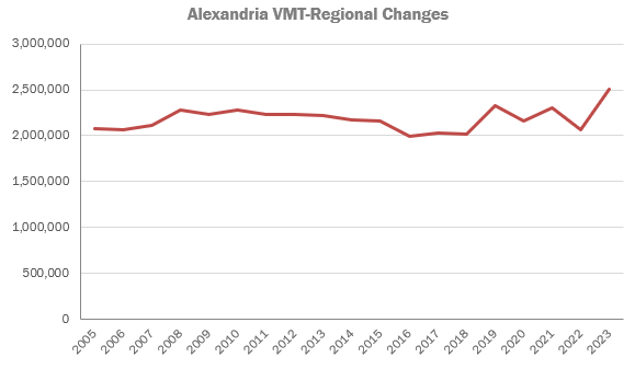
The sheet VMT per Capita shows population and VMT per capita for several years up until the most recent 2023 data for the Planning Region. See below line graph for Alexandria specific VMT data.
VMT for 2023 in Alexandria was 2,509,018 trips which was an increase from 2022. 14% of these trips were local trips with 86% being non-local trips.
The increase was mostly due to added road segment data which was previously unavailable, in non-state maintained roads. Changes in future years are not expected to be as large. VMT trends in Alexandria largely match other regional core cities and municipalities.

Annual Report and Work Plan
Each year, the City develops an annual report and work plan for the Long-Range Transportation Planning Program.
Coordination with Other Agencies
The Long-Range Transportation Planning team coordinates and provides input on regional and City-wide projects as needed. Agency coordination is on-going with groups such as DASH, Virginia Passenger Rail Authority, Virginia Railway Express, and the Virginia Department of Transportation.
For more information, see the pages below.
REGIONAL TRANSPORTATION PROJECTS PAGE
EXPRESS LANES PROJECTS PAGE
Small Area Plans
The Department of Planning and Zoning leads updates to the city's Comprehensive Master Plan, typically focused on areas of the City that are experiencing significant growth or development. The Long Range Transportation Planning team provides inputs on the transportation vision and recommendations with each plan update. The following are adopted Small Area Plans:
- North Potomac Yard - 2017
- South Patrick Street - 2018
- Eisenhower East Plan Update - 2019
- Landmark/Van Dorn Re-Planning - 2019
- Arlandria-Chirilagua - 2021
- AlexWest Small Area Plan- 2024
Additional Resources
Visit the resources below to learn more: