Wayfinding Signs and Self-Guided Tours


About the Alexandria Heritage Trail
There are many ways to access stories about the archaeology and history of Alexandria. Historic interpretation signs written and installed by preservation partners dot Alexandria’s landscape and ensure that the people, places, and pieces of the past are accessible for residents and visitors.
The Alexandria Heritage Trail continues to grow, with new signs added each year.
Heritage Trail Signs
Historical markers continue to be placed at new locations in the City of Alexandria. See below for an alphabetical listing, and for special groups of signs at Jones Point, Fort Ward Park, Chinquapin Park, Del Ray and more.
- Timeline of Alexandria History (City Dock behind the Torpedo Factory Art Center, in the shopping arcade on the south end toward King Street)
- African American Heritage Park (500 Holland Lane)
- African American Heritage Park (orientation sign, 1 and 7 on map)
- Sanctuary (sign 2 on map)
- Freedom (sign 3 on map)
- Civil Rights (sign 4 on map)
- Remembrance (sign 6 on map)
- African American Waterfront Heritage Trail
North Trail - African American Waterfront Heritage Trail
South Trail - Alexandria Canal (901 N. Fairfax Street)
- Alexandria Canal (525 Montgomery Street)
- Alexandria Library Sit-In (711 Queen Street, outside of Barrett Library)
- Alexandria War Memorial(Alexandria Union Station, 110 Callahan Drive)
- The Baggett and Hellmuth Slaughterhouse (1501 Cameron Street)
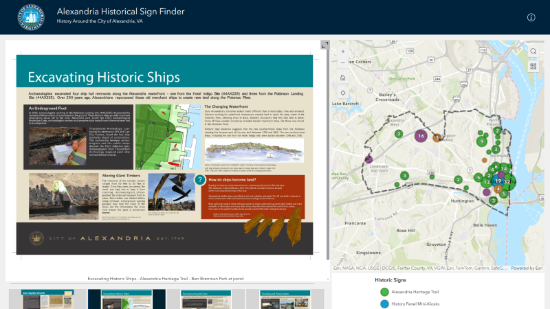
- Ben Brenman Park Signs: Historic Ship Preservation(4800 Brenman Park Drive)
- The Berg (600 block N. Royal Street)
- Bloxham Family Cemetery(116 South Quaker Lane)
- Bloxham Cemetery: Portal to the Past (116 South Quaker Lane)
- Cameron Valley (Meridian at Eisenhower Apartments - 2351 Eisenhower Ave)
- Carver Nursery School/Post 129 (224 N. Fayette Street)
- Chinquapin Park Trail Signs (3210 King Street)
- City Jail: A Site of Racial Terror in Alexandria (401 N. S. Asaph Street)
- Del Ray and the Town of Potomac Trail Signs
- The Town of Potomac (Mount Vernon Avenue)
- Mount Vernon Avenue (Farmer’s Market, East Oxford & Mount Vernon avenues)
- The Electric Railway (Mount Vernon Community School, 2601 Commonwealth Avenue, on the west side)
- Schools in the Town of Potomac (Mount Vernon Community School, 2601 Commonwealth Avenue, on the Mount Vernon Avenue side
- St. Asaph Racetrack (Charles Hill Park, East Oxford & DeWitt avenues)
- The Bluemont Line (Mount Jefferson Park, 200 block of East Raymond Avenue)
- The Alexandria Almshouse (Simpson Stadium Park, 426 East Monroe Avenue)
- Potomac Town Hall and Firehouse (Fire Station 202, 213 East Windsor Avenue)
- 1323 Duke Street -- From Slavery to Freedom and Service (1323 Duke Street)
- The Edmonson Sisters (1707 Duke Street, in front of the Bruin Slave Pen building)
- The First Minnie Howard School (1954-2024) (3775 West Braddock Road)
- The First Parker-Gray School(901 Wythe Street, in front of Charles-Houston Recreation Center)
- Foot of King Street (Waterfront Park)
- Ford's Landing Park (on the waterfront walkway east end of Franklin Street)
- Fort Ward Park Trail Signs (4301 West Braddock Road)
- From Civil War to Civil Rights. A timeline of the African American community, "The Fort," established here from after the Civil War and continuing into the Civil Rights Era of the 1960s.
- African Americans and the Civil War. Fleeing, fighting and working for freedom.
- Within Its Walls -- A Foundation for Education and Opportunity. The community's children were educated in the one-room "Colored School Building at Seminary, and later at the Seminary School for African Americans.
- The Oakland Baptist Church. Several members of The Fort were founders of the Oakland Baptist Church.
- The Oakland Baptist Church Cemetery. Originally a small family cemetery, the land was conveyed to the Oakland Baptist Church in 1939.
- The Jackson Cemetery. In 1884, James F. Jackson purchased the largest parcel in The Fort. The Jacksons later established a cemetery on part of the land.
- The Growth of Upper King Street(1300 King Street)
- Hoof's Run Bridge (in the African American Heritage Park, Duke Street and Holland Lane)
- Industrialization on the Strand (211 Strand, Watermark Condominiums)
- Jones Point Park Trail Signs (1 Jones Point Park, accessed from south end of Royal Street.
The National Park Service installed 17 historic markers in the park. - Lafayette in Alexandria (301 S. St. Asaph Street)
- Keith's Wharf (Between Powhatan Park and Jones Point Park)
- Potomac Yard (2501 Potomac Avenue)
- Virginia's First Highways. Native Americans in the area of Potomac Yard.
- The Alexanders and Agriculture. The first European land owners.
- Building Potomac Yard. The Yard opened in 1906.
- The People of Potomac Yard. As many as 1,500 employees worked at Potomac Yard.
- Crossroads of Transportation. Roads, passenger rail and the Canal also crossed through the Yard.
- The Rail Yard Hump. The Hump played a crucial role in switching and classifying the freight cars.
- Potomac Yard in Transition. The Yard closed in 1982, and is the site of ongoing development of homes and businesses along Route 1 in Alexandria and Arlington.
- Ramsey Homes (North Patrick Street between Pendleton and Wythe Streets)
- Ramsey Homes Civil War & Archaeology of the Block (North Patrick Street between Pendleton and Wythe Streets)
- Star-Spangled Banner Trail, developed by the National Park Service, commemorate the War of 1812.
- "Raise the White Flag" (Waterfront Park, 1a Prince Street)
- "Plundered" (Torpedo Factory arcade, 101 N. Union Street, near the Timeline)
- "Fighting Back" (Base of Shuter's Hill, across from the Callahan Drive crosswalk)
- The Student-Athletes of Parker-Gray High School (900-block Madison Street, behind Charles-Houston Recreation Center)
- Suffragists and a Courtroom Decision in Alexandria (SW corner of Prince & St. Asaph streets)
- Waterfront Archaeology (211 Strand, Watermark Condominiums)
- The West End (in the African American Heritage Park, Duke Street and Holland Lane)
- Wilkes Street Tunnel (on the path to the tunnel on Wilkes Street, at the entrance to the tunnel near S. Lee Street)
- Windmill Hill (at entrance to park on S. Union Street, between Wolfe and Gibbon Street)
- Zion Baptist Church (South Lee Street)